

2. Mangatawa catchment consents for earthworks, storm water ...
2. Mangatawa catchment consents for earthworks, storm water ...
2. Mangatawa catchment consents for earthworks, storm water ...
- No tags were found...

Create successful ePaper yourself
Turn your PDF publications into a flip-book with our unique Google optimized e-Paper software.
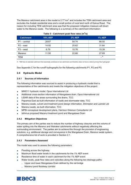
The Maranui <strong>catchment</strong> area in the model is <strong>2.</strong>77 km 2 and includes the TEM <strong>catchment</strong> area and<br />
excludes the Arataki residential area and a small portion of rural land north of Kairua Road. The<br />
reason <strong>for</strong> including TEM <strong>catchment</strong> area was that the proposed mitigation measure will divert<br />
<strong>water</strong> to the Maranui swale. The following is a summary of the <strong>catchment</strong> in<strong>for</strong>mation:<br />
Table 5 - Catchment peak flow rates (m 3 /s)<br />
Catchment 10% AEP 2% AEP 1% AEP<br />
P1 – central 28.67 54.74 66.50<br />
P2 – east 14.92 25.62 31.64<br />
P3 – west 6.79 10.76 15.39<br />
Maranui 11.50 2<strong>2.</strong>66 27.69<br />
TEM<br />
- A<br />
A – TEM has an extended <strong>catchment</strong> that essentially contributes to two <strong>catchment</strong>s and there<strong>for</strong>e does not have a distinct primary flow hydrograph.<br />
See Appendix C <strong>for</strong> the runoff hydrographs <strong>for</strong> the following <strong>catchment</strong>s P1, P2 and P3.<br />
<strong>2.</strong>4 Hydraulic Model<br />
<strong>2.</strong>4.1 Sources of In<strong>for</strong>mation<br />
The following in<strong>for</strong>mation was sourced to assist in producing a hydraulic model that is<br />
representative of the <strong>catchment</strong>s and meets the mitigation objectives of the project:<br />
• MIKE11 hydraulic model, Opus International Ltd<br />
• Additional cross-section in<strong>for</strong>mation of <strong>Mangatawa</strong> drain, Opus International Ltd<br />
• LiDAR data of the areas surrounding the drains, TCC<br />
• Papamoa East as-built in<strong>for</strong>mation of roads and <strong>storm</strong><strong>water</strong> data, TCC<br />
• Maranui swale, culvert and treatment pond design in<strong>for</strong>mation, Shrimpton and Lipinski Ltd<br />
• Maranui swale, as-built in<strong>for</strong>mation, TCC<br />
• MPBI conceptual development plans, Harrison Grierson Consultants Ltd<br />
• Isthmus proposed Maranui treatment pond and <strong>Mangatawa</strong> Drain<br />
<strong>2.</strong>4.2 Mitigation Objectives<br />
The primary aim of the parties was to reduce the number of highway closures and the volume of<br />
<strong>water</strong> spilling into the Maranui and Wairakei <strong>catchment</strong>s without negatively affecting the<br />
surrounding environment. The parties aim to achieve this through the provision of engineering<br />
solutions, e.g. additional storage and conveyance in the <strong>Mangatawa</strong> Drain, Maranui swale system.<br />
A comprehensive list of work is provided in Section <strong>2.</strong>1.<br />
<strong>2.</strong>4.3 Parameters Assessed<br />
The model was used to assess the following parameters:<br />
• Flooding across the highway<br />
• Maximum flood <strong>water</strong> levels in the <strong>catchment</strong>s <strong>for</strong> the 1% AEP event<br />
• Residence time of <strong>water</strong> in each <strong>catchment</strong> <strong>for</strong> the 1% AEP event<br />
• Water levels, peak flow rates and velocities along the following two drainage paths:<br />
Upper and lower <strong>Mangatawa</strong> Drain defined by the rail bridge<br />
-<br />
-<br />
Maranui pond floodway corridor<br />
Beca // 17 March 2009 // Page 10<br />
3932036 // NZ1-1604459-15 0.15 Rev A


