

2. Mangatawa catchment consents for earthworks, storm water ...
2. Mangatawa catchment consents for earthworks, storm water ...
2. Mangatawa catchment consents for earthworks, storm water ...
- No tags were found...

You also want an ePaper? Increase the reach of your titles
YUMPU automatically turns print PDFs into web optimized ePapers that Google loves.
NZ Transport Agency and Tauranga City Council<br />
<strong>Mangatawa</strong> Drain Flood Bypass and TEM Storm<strong>water</strong> AEE<br />
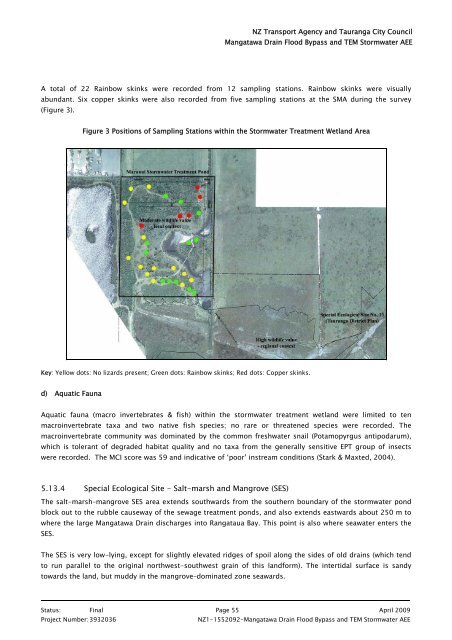
A total of 22 Rainbow skinks were recorded from 12 sampling stations. Rainbow skinks were visually<br />
abundant. Six copper skinks were also recorded from five sampling stations at the SMA during the survey<br />
(Figure 3).<br />
Figure 3 Positions of Sampling Stations within the Storm<strong>water</strong> Treatment Wetland Area<br />
Key: Yellow dots: No lizards present; Green dots: Rainbow skinks; Red dots: Copper skinks.<br />
d) Aquatic Fauna<br />
Aquatic fauna (macro invertebrates & fish) within the <strong>storm</strong><strong>water</strong> treatment wetland were limited to ten<br />
macroinvertebrate taxa and two native fish species; no rare or threatened species were recorded. The<br />
macroinvertebrate community was dominated by the common fresh<strong>water</strong> snail (Potamopyrgus antipodarum),<br />
which is tolerant of degraded habitat quality and no taxa from the generally sensitive EPT group of insects<br />
were recorded. The MCI score was 59 and indicative of ‘poor’ instream conditions (Stark & Maxted, 2004).<br />
5.13.4 Special Ecological Site - Salt-marsh and Mangrove (SES)<br />
The salt-marsh–mangrove SES area extends southwards from the southern boundary of the <strong>storm</strong><strong>water</strong> pond<br />
block out to the rubble causeway of the sewage treatment ponds, and also extends eastwards about 250 m to<br />
where the large <strong>Mangatawa</strong> Drain discharges into Rangataua Bay. This point is also where sea<strong>water</strong> enters the<br />
SES.<br />
The SES is very low-lying, except <strong>for</strong> slightly elevated ridges of spoil along the sides of old drains (which tend<br />
to run parallel to the original northwest-southwest grain of this land<strong>for</strong>m). The intertidal surface is sandy<br />
towards the land, but muddy in the mangrove–dominated zone seawards.<br />
Status: Final Page 55 April 2009<br />
Project Number: 3932036<br />
NZ1-1552092-<strong>Mangatawa</strong> Drain Flood Bypass and TEM Storm<strong>water</strong> AEE


