

Airborne Gravity 2010 - Geoscience Australia
Airborne Gravity 2010 - Geoscience Australia
Airborne Gravity 2010 - Geoscience Australia

Create successful ePaper yourself
Turn your PDF publications into a flip-book with our unique Google optimized e-Paper software.
<strong>Airborne</strong> <strong>Gravity</strong> <strong>2010</strong><br />
Even though weather was identified at the outset as the most significant risk factor, this factor only<br />
affected production for 14% of the survey program. Analysis of the breakdown figures over time<br />
revealed that the majority of the weather impacts on productivity occurred in the summer months,<br />
when inclement weather related to storm activity was more prevalent. The weather downtime was<br />
increased by the lack of weather radar and reliable forecasts in Botswana. The pilots had to err on the<br />
side of caution at times and often didn’t fly due to the risk of a fast approaching storm. Mobile weather<br />
stations that could transmit data via the mobile telephone network were deployed at high points<br />
(telecommunications towers etc.) around the survey area to assist in the safety mitigation.<br />
Even with the caution exercised during inclement weather, there was one serious incident where a<br />
severe updraft was experienced which violently lifted the airship above its planned flight-path.<br />
Although there were no injuries, the incident caused structural damage to the airship which in turn<br />
caused several months of unexpected downtime before the repairs could be completed. In total, 16%<br />
of the project duration was lost while waiting for hangar availability.<br />
The statutory annual inspections consumed 8% of the available flying days, and the Bell instrument<br />
was down 5% of the time.<br />
Value-Add of Airship Data<br />
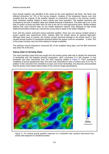
The most important output that was sought from the airship gravity data was to identify the responses<br />
of kimberlites with the targeted physical parameters. Upon conclusion of a drill program, a new<br />
kimberlite had been discovered from the AGG response plotted in Figure 5. From constrained<br />
modelling of ground geophysical data, this body was interpreted to have a surface area of 2.0 Ha. In<br />
addition to the outcomes from orientation surveys over known kimberlites, this discovery demonstrated<br />
that the airship could indeed detect bodies of the minimum target specifications.<br />
Figure 5. Tzz vertical gravity gradient response of a kimberlite (star symbol) discovered from<br />
airship data adjacent to a faulted boundary<br />
103


