

Airborne Gravity 2010 - Geoscience Australia
Airborne Gravity 2010 - Geoscience Australia
Airborne Gravity 2010 - Geoscience Australia

Create successful ePaper yourself
Turn your PDF publications into a flip-book with our unique Google optimized e-Paper software.
<strong>Airborne</strong> <strong>Gravity</strong> <strong>2010</strong><br />
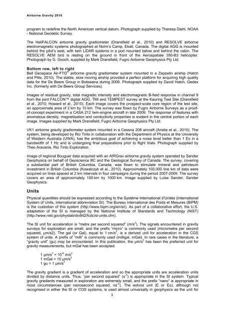
program to redefine the North American vertical datum. Photograph supplied by Theresa Diehl, NOAA<br />
- National Geodetic Survey.<br />
The HeliFALCON airborne gravity gradiometer (Dransfield et al., <strong>2010</strong>) and RESOLVE airborne<br />
electromagnetic systems photographed at Norm’s Camp, Ekati, Canada. The digital AGG is mounted<br />
behind the pilot’s seat, with twin LiDAR systems in a pod mounted below and behind the cabin. The<br />
RESOLVE AEM bird is resting on the ground in front of the Aerospatiale 350-B3 helicopter.<br />
Photograph by G. Gooch, supplied by Mark Dransfield, Fugro <strong>Airborne</strong> Geophysics Pty Ltd.<br />
Bottom row, left to right<br />
Bell Geospace Air-FTG ® airborne gravity gradiometer system mounted in a Zeppelin airship (Hatch<br />
and Pitts, <strong>2010</strong>). The stable, slow moving airship provided a perfect platform for acquiring high quality<br />
data for the De Beers Group in Botswana during 2006. Photograph supplied by David Hatch, Gedex<br />
Inc. (formerly with De Beers Group Services).<br />
Images of residual gravity, total magnetic intensity and electromagnetic B-field response in channel 9<br />
from the joint FALCON digital AGG, TMI and TEMPEST survey at the Kauring Test Site (Dransfield<br />
et al., <strong>2010</strong>; Howard et al., <strong>2010</strong>). Each image covers the prospect-scale core region of the test site,<br />
an approximate area of 2 km by 10 km. The survey was flown by Fugro <strong>Airborne</strong> Surveys as a proofof-concept<br />
experiment in a CASA 212 twin-engine aircraft in late 2009. The response of features with<br />
anomalous density, magnetisation and conductivity properties is evident in the central portion of each<br />
image. Images supplied by Mark Dransfield, Fugro <strong>Airborne</strong> Geophysics Pty Ltd.<br />
VK1 airborne gravity gradiometer system mounted in a Cessna 208 aircraft (Anstie et al., <strong>2010</strong>). The<br />
system, being developed by Rio Tinto in collaboration with the Department of Physics at the University<br />
of Western <strong>Australia</strong> (UWA), has the ambitious goal of achieving a noise level better than 1 Eo in a<br />
bandwidth of 1 Hz and is undergoing final preparations prior to flight trials. Photograph supplied by<br />
Theo Aravanis, Rio Tinto Exploration.<br />
Image of regional Bouguer data acquired with an AIRGrav airborne gravity system operated by Sander<br />
Geophysics on behalf of <strong>Geoscience</strong> BC and the Geological Survey of Canada. The survey, covering<br />
a substantial part of British Columbia, Canada, was flown to stimulate mineral and petroleum<br />
investment in British Columbia (Kowalczyk et al., <strong>2010</strong>). Approximately 100,000 line km of data were<br />
acquired on lines spaced at 2 km intervals in four campaigns during the period 2007-2009. The survey<br />
covers an area of approximately 150 km by 1000 km. Image supplied by Luise Sander, Sander<br />
Geophysics.<br />
Units<br />
Physical quantities should be expressed according to the Système International d'Unités (International<br />
System of Units, international abbreviation SI). The Bureau International des Poids et Mesures (BIPM)<br />
is the custodian of this system (http://www.bipm.org/en/si/). As part of a collaborative effort, the U.S.<br />
adaptation of the SI is managed by the National Institute of Standards and Technology (NIST)<br />
(http://www.nist.gov/physlab/div842/fcdc/si-units.cfm).<br />
The SI unit for acceleration is “metre per second squared” (m/s 2 ). The signals encountered in gravity<br />
surveys for exploration are small, and the prefix “micro” is commonly used (micrometre per second<br />
squared, μm/s2). The gal (or Gal), equal to 1 cm/s 2 , is a derived unit for acceleration in the CGS<br />
system of units. A prefix of “milli” is commonly used (milligal, mGal). In rare cases in the literature, a<br />
“gravity unit” (gu) may be encountered. In this publication, the μm/s 2 has been the preferred unit for<br />
gravity measurements, but mGal has been accepted.<br />
1 μm/s 2 = 10 -6 m/s 2<br />
1 mGal = 10 μm/s 2<br />
1 gu = 1 μm/s 2<br />
The gravity gradient is a gradient of acceleration and so the appropriate units are acceleration units<br />
divided by distance units. Thus, “per second squared” (s -2 ) is appropriate in the SI system. Typical<br />
gravity gradients measured in exploration are extremely small, and the prefix “nano” is appropriate in<br />
most circumstances (per nanosecond squared, ns -2 ). The eotvos unit (E or Eo), although not<br />
recognised in either the SI or CGS systems, is used almost universally in geophysics as the unit for<br />
3


