

Airborne Gravity 2010 - Geoscience Australia
Airborne Gravity 2010 - Geoscience Australia
Airborne Gravity 2010 - Geoscience Australia

You also want an ePaper? Increase the reach of your titles
YUMPU automatically turns print PDFs into web optimized ePapers that Google loves.
<strong>Airborne</strong> <strong>Gravity</strong> <strong>2010</strong><br />
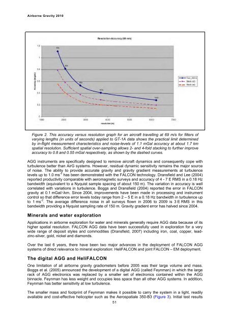
Figure 2. This accuracy versus resolution graph for an aircraft travelling at 69 m/s for filters of<br />
varying lengths (in units of seconds) applied to GT-1A data shows the practical limit determined<br />
by in-flight measurement characteristics and noise-levels of 1.1 mGal accuracy at about 1.7 km<br />
spatial resolution. Sufficient spatial over-sampling allows 2- and 4-fold stacking to further improve<br />
accuracy to 0.8 and 0.55 mGal respectively, as shown by the dashed curves.<br />
AGG instruments are specifically designed to remove aircraft dynamics and consequently cope with<br />
turbulence better than AirG systems. However, residual dynamic sensitivity remains the major source<br />
of noise. The ability to provide accurate gravity and gravity gradient measurements at turbulence<br />
levels up to 1.0 ms -2 has been demonstrated with the FALCON technology. Dransfield and Lee (2004)<br />
reported productivity comparable with aeromagnetic surveys and accuracy of 4 - 7 E RMS in a 0.18 Hz<br />
bandwidth (equivalent to a Nyquist sample spacing of about 150 m). The variation in accuracy is well<br />
correlated with variations in turbulence. Boggs and Dransfield (2004) reported the error in FALCON<br />
gravity at 0.1 mGal/√km. Since 2004, improvements have been made in processing and instrument<br />
control so that difference error levels today range from 2 – 5 E in a 0.18 Hz bandwidth in turbulence up<br />
to 1 ms -2 . The average difference noise in all surveys flown in 2006 to 2009 is 3 E RMS in this<br />
bandwidth providing a Nyquist sampling rate of 150 m. <strong>Gravity</strong> gradient error has halved since 2004.<br />
Minerals and water exploration<br />
Applications in airborne exploration for water and minerals generally require AGG data because of its<br />
higher spatial resolution. FALCON AGG data have been successfully used in exploration for a very<br />
wide range of deposit styles and commodities (Dransfield, 2007) including iron, coal, copper, leadzinc-silver,<br />
gold, nickel and diamonds.<br />
Over the last 6 years, there have been two major advances in the deployment of FALCON AGG<br />
systems of direct relevance to mineral exploration: HeliFALCON and joint FALCON – EM deployment.<br />
The digital AGG and HeliFALCON<br />
One limitation of all airborne gravity gradiometers before 2005 was their large volume and mass.<br />
Boggs et al. (2005) announced the development of a digital AGG (called Feynman) in which the large<br />
rack of AGG electronics was replaced by a smaller set of electronics contained within the AGG<br />
binnacle. Feynman has less weight and occupies less space than all other AGG systems. In addition,<br />
Feynman has better sensitivity at low turbulence.<br />
The smaller mass and footprint of Feynman makes it possible to carry the system in a light, readily<br />
available and cost-effective helicopter such as the Aerospatiale 350-B3 (Figure 3). Initial test results<br />
51


