

Airborne Gravity 2010 - Geoscience Australia
Airborne Gravity 2010 - Geoscience Australia
Airborne Gravity 2010 - Geoscience Australia

Create successful ePaper yourself
Turn your PDF publications into a flip-book with our unique Google optimized e-Paper software.
<strong>Airborne</strong> <strong>Gravity</strong>, <strong>2010</strong><br />
(a)<br />
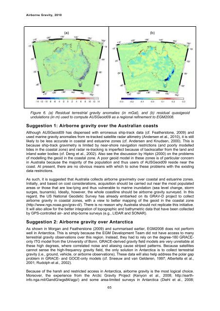
Figure 6. (a) Residual terrestrial gravity anomalies (in mGal), and (b) residual quasigeoid<br />
undulations (in m) used to compute AUSGeoid09 as a regional refinement to EGM2008.<br />
Suggestion 1: <strong>Airborne</strong> gravity over the <strong>Australia</strong>n coasts<br />
Although AUSGeoid09 has dispensed with erroneous ship-track data (cf. Featherstone, 2009) and<br />
used marine gravity anomalies from re-tracked satellite radar altimetry (Andersen et al., <strong>2010</strong>), it is still<br />
likely to be less accurate in coastal and estuarine zones (cf. Andersen and Knudsen, 2000). This is<br />
because ship-track gravimetry is limited by near-shore navigation restrictions (and poorly modelled<br />
tides in the coastal zone) and radar re-tracking is imperfect because of backscatter from the land and<br />
inland water bodies (cf. Deng et al., 2002). Also see the discussion by Hipkin (2000) on the problems<br />
of modelling the geoid in the coastal zone. A poor geoid model in these zones is of particular concern<br />
in <strong>Australia</strong> because the majority of the population and thus users of AUSGeoid09 reside near the<br />
coast. At present, there are no obvious means with which to solve these problems with the existing<br />
data restrictions.<br />
As such, it is suggested that <strong>Australia</strong> collects airborne gravimetry over coastal and estuarine zones.<br />
Initially, and based on cost considerations, acquisition should be carried out near the most populated<br />
areas or those that are low-lying and thus vulnerable to marine inundation (sea level change, storm<br />
surges, tsunamis). Ideally, however, the whole coastline should be airborne gravity surveyed. In this<br />
regard, the US National Geodetic Survey has already embarked on its GRAV-D project to collect<br />
airborne gravity in coastal zones, with a view to better mapping of the geoid in the coastal zone<br />
(http://www.ngs.noaa.gov/grav-d/). There is no reason why <strong>Australia</strong> should not replicate this initiative.<br />
It will also allow for the better integration of topographic and bathymetric data that have been collected<br />
by GPS-controlled air- and ship-borne surveys (e.g., LIDAR and SONAR).<br />
Suggestion 2: <strong>Airborne</strong> gravity over Antarctica<br />
As shown in Morgan and Featherstone (2009) and summarised earlier, EGM2008 does not perform<br />
well in Antarctica. This is simply because the EGM Development Team did not have access to many<br />
terrestrial gravity observations over this region. Instead, they had to rely on the degree-180 GRACEonly<br />
ITG model from the University of Bonn. GRACE-derived gravity field models are very unreliable at<br />
these high degrees, where correlated noise and aliasing cause striped patterns. Because satellites<br />
cannot sense the high-frequency gravity field, the only solution in Antarctica is to collect terrestrial<br />
gravity (i.e., ground, vehicle, or airborne observations). These data will also help address the polar gap<br />
problem in GRACE- and GOCE-only models (cf. Sneeuw and van Gelderen, 1997; Albertella et al.,<br />
2001; Rudolph et al., 2002).<br />
Because of the harsh and restricted access in Antarctica, airborne gravity is the most logical choice.<br />
Moreover, the experience from the Arctic <strong>Gravity</strong> Project (Kenyon et al., 2008; http://earthinfo.nga.mil/GandG/wgs84/agp/)<br />
and some area-limited surveys in Antarctica (Diehl et al., 2008;<br />
65<br />
(b)


