

Airborne Gravity 2010 - Geoscience Australia
Airborne Gravity 2010 - Geoscience Australia
Airborne Gravity 2010 - Geoscience Australia

Create successful ePaper yourself
Turn your PDF publications into a flip-book with our unique Google optimized e-Paper software.
<strong>Airborne</strong> <strong>Gravity</strong>, <strong>2010</strong><br />
the use of a low-Earth orbiting (~250 km) gradiometer, and based on numerous simulations, it should<br />
be able to determine the static gravity field to an accuracy of ~1 mGal in terms of gravity anomalies<br />
and ~1-2 cm in terms of geoid undulations (cf. Tscherning et al., 2002) down to spatial scales of<br />
~100 km. A geoid model of this accuracy is important as a global reference surface for geodesy (e.g.,<br />
unification of height datums), and studies of Earth-interior processes, ocean current circulation, ice<br />
motion and sea-level change, among others.<br />
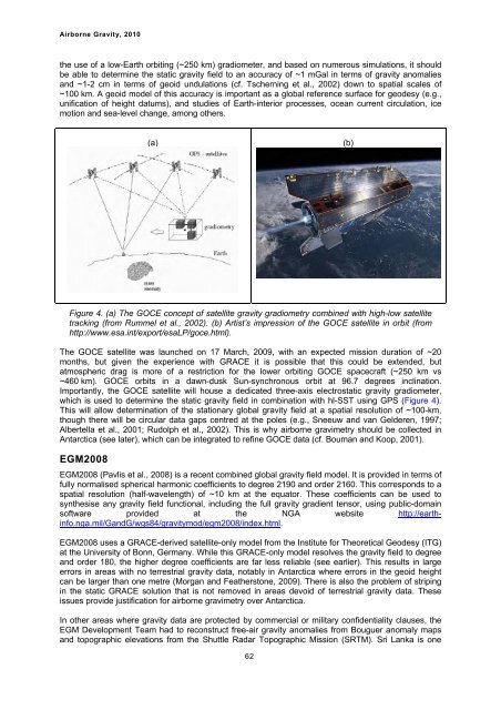
(a)<br />
Figure 4. (a) The GOCE concept of satellite gravity gradiometry combined with high-low satellite<br />
tracking (from Rummel et al., 2002). (b) Artist’s impression of the GOCE satellite in orbit (from<br />
http://www.esa.int/export/esaLP/goce.html).<br />
The GOCE satellite was launched on 17 March, 2009, with an expected mission duration of ~20<br />
months, but given the experience with GRACE it is possible that this could be extended, but<br />
atmospheric drag is more of a restriction for the lower orbiting GOCE spacecraft (~250 km vs<br />
~460 km). GOCE orbits in a dawn-dusk Sun-synchronous orbit at 96.7 degrees inclination.<br />
Importantly, the GOCE satellite will house a dedicated three-axis electrostatic gravity gradiometer,<br />
which is used to determine the static gravity field in combination with hl-SST using GPS (Figure 4).<br />
This will allow determination of the stationary global gravity field at a spatial resolution of ~100-km,<br />
though there will be circular data gaps centred at the poles (e.g., Sneeuw and van Gelderen, 1997;<br />
Albertella et al., 2001; Rudolph et al., 2002). This is why airborne gravimetry should be collected in<br />
Antarctica (see later), which can be integrated to refine GOCE data (cf. Bouman and Koop, 2001).<br />
EGM2008<br />
EGM2008 (Pavlis et al., 2008) is a recent combined global gravity field model. It is provided in terms of<br />
fully normalised spherical harmonic coefficients to degree 2190 and order 2160. This corresponds to a<br />
spatial resolution (half-wavelength) of ~10 km at the equator. These coefficients can be used to<br />
synthesise any gravity field functional, including the full gravity gradient tensor, using public-domain<br />
software provided at the NGA website http://earthinfo.nga.mil/GandG/wgs84/gravitymod/egm2008/index.html.<br />
EGM2008 uses a GRACE-derived satellite-only model from the Institute for Theoretical Geodesy (ITG)<br />
at the University of Bonn, Germany. While this GRACE-only model resolves the gravity field to degree<br />
and order 180, the higher degree coefficients are far less reliable (see earlier). This results in large<br />
errors in areas with no terrestrial gravity data, notably in Antarctica where errors in the geoid height<br />
can be larger than one metre (Morgan and Featherstone, 2009). There is also the problem of striping<br />
in the static GRACE solution that is not removed in areas devoid of terrestrial gravity data. These<br />
issues provide justification for airborne gravimetry over Antarctica.<br />
In other areas where gravity data are protected by commercial or military confidentiality clauses, the<br />
EGM Development Team had to reconstruct free-air gravity anomalies from Bouguer anomaly maps<br />
and topographic elevations from the Shuttle Radar Topographic Mission (SRTM). Sri Lanka is one<br />
62<br />
(b)


