

Airborne Gravity 2010 - Geoscience Australia
Airborne Gravity 2010 - Geoscience Australia
Airborne Gravity 2010 - Geoscience Australia

You also want an ePaper? Increase the reach of your titles
YUMPU automatically turns print PDFs into web optimized ePapers that Google loves.
<strong>Airborne</strong> <strong>Gravity</strong> <strong>2010</strong><br />
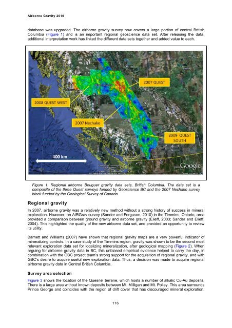
database was upgraded. The airborne gravity survey now covers a large portion of central British<br />
Columbia (Figure 1) and is an important regional geoscience data set. After releasing the data,<br />
additional interpretation work has linked the different data sets together and added value to each.<br />
Figure 1. Regional airborne Bouguer gravity data sets, British Columbia. The data set is a<br />
composite of the three Quest surveys funded by <strong>Geoscience</strong> BC and the 2007 Nechako survey<br />
block funded by the Geological Survey of Canada.<br />
Regional gravity<br />
In 2007, airborne gravity was a relatively new method without a strong history of success in mineral<br />
exploration. However, an AIRGrav survey (Sander and Ferguson, <strong>2010</strong>) in the Timmins, Ontario, area<br />
provided a comparison between ground gravity and airborne gravity (Elieff, 2003; Sander and Elieff,<br />
2004). This highlighted the quality of the new airborne data set, and provided an opportunity to review<br />
its utility.<br />
Barnett and Williams (2007) have shown that regional gravity maps are a very powerful indicator of<br />
mineralizing controls. In a case study of the Timmins region, gravity was shown to be the second most<br />
relevant exploration data set for localizing mineralization, after geological mapping (Figure 2). When<br />
arguing for airborne gravity data in BC, this unbiased empirical evidence helped to carry the day, in<br />
combination with the GBC project team’s strong support for the acquisition of regional gravity, and with<br />
GBC’s desire to acquire useful new exploration data. Thus, a decision was made to acquire regional<br />
airborne gravity data in Central British Columbia.<br />
Survey area selection<br />
Figure 3 shows the location of the Quesnel terrane, which hosts a number of alkalic Cu-Au deposits.<br />
There is a large area without known deposits between Mt. Milligan and Mt. Polley. This area surrounds<br />
Prince George and coincides with the region of drift cover that has discouraged mineral exploration.<br />
116


