

Airborne Gravity 2010 - Geoscience Australia
Airborne Gravity 2010 - Geoscience Australia
Airborne Gravity 2010 - Geoscience Australia

You also want an ePaper? Increase the reach of your titles
YUMPU automatically turns print PDFs into web optimized ePapers that Google loves.
<strong>Airborne</strong> <strong>Gravity</strong> <strong>2010</strong><br />
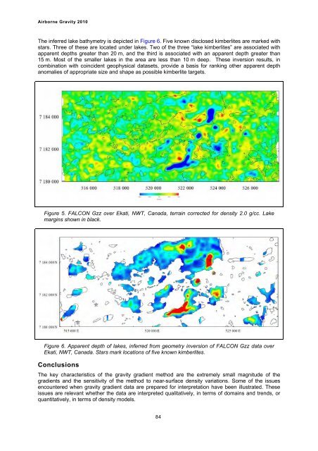
The inferred lake bathymetry is depicted in Figure 6. Five known disclosed kimberlites are marked with<br />
stars. Three of these are located under lakes. Two of the three “lake kimberlites” are associated with<br />
apparent depths greater than 20 m, and the third is associated with an apparent depth greater than<br />
15 m. Most of the smaller lakes in the area are less than 10 m deep. These inversion results, in<br />
combination with coincident geophysical datasets, provide a basis for ranking other apparent depth<br />
anomalies of appropriate size and shape as possible kimberlite targets.<br />
Figure 5. FALCON Gzz over Ekati, NWT, Canada, terrain corrected for density 2.0 g/cc. Lake<br />
margins shown in black.<br />
Figure 6. Apparent depth of lakes, inferred from geometry inversion of FALCON Gzz data over<br />
Ekati, NWT, Canada. Stars mark locations of five known kimberlites.<br />
Conclusions<br />
The key characteristics of the gravity gradient method are the extremely small magnitude of the<br />
gradients and the sensitivity of the method to near-surface density variations. Some of the issues<br />
encountered when gravity gradient data are prepared for interpretation have been illustrated. These<br />
issues are relevant whether the data are interpreted qualitatively, in terms of domains and trends, or<br />
quantitatively, in terms of density models.<br />
84


