

Airborne Gravity 2010 - Geoscience Australia
Airborne Gravity 2010 - Geoscience Australia
Airborne Gravity 2010 - Geoscience Australia

Create successful ePaper yourself
Turn your PDF publications into a flip-book with our unique Google optimized e-Paper software.
<strong>Airborne</strong> <strong>Gravity</strong> <strong>2010</strong><br />
Operational improvements - turbulence and noise<br />
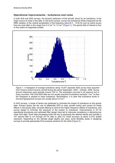
In both AirG and AGG surveys, the dynamic behaviour of the aircraft, driven by air turbulence, is the<br />
major source of noise in the data. In low-level surveys, survey line turbulence levels (measured as the<br />
RMS variation of the vertical acceleration in the frequency band [0.3 – 10.0] Hz over an entire survey<br />
line) are most often in the range from 0.4 ms -2 to 1.0 ms -2 (Figure 1). The gravity field of interest is four<br />
or five orders of magnitude smaller.<br />
Figure 1. A histogram of average turbulence along 14,437 separate AGG survey lines acquired<br />
from Cessna Grand Caravan aircraft during the period September, 2004 – October, 2008. Survey<br />
ground clearances were typically around 100 m. The acquisition occurred in all seasons and in<br />
many countries. FALCON AGG data are not usually acquired if turbulence exceeds 1 ms -2 so that<br />
the histogram is skewed to lower turbulence. Nevertheless, it is clear that turbulence levels in<br />
low-level geophysical surveys are usually above 0.4 ms -2 .<br />
In AirG surveys, a range of tactics are employed to minimise the impact of turbulence on the gravity<br />
data. Primary tactics are the use of differential GPS to track aircraft motion and correct for these<br />
effects in the gravity data, low-pass filtering to remove the higher frequency effects of turbulence, and<br />
survey design to minimise the exposure of the system to turbulence. Improvements in GT-1A<br />
operational procedures and optimised filter design have led to improved consistency in delivering low<br />
noise AirG data. Good data processing holds the key to producing the desired results and typically a<br />
107 second filter is run through GT-1A data to yield 0.5 mGal accuracy at about 3.5 km spatial<br />
resolution. Depending on the ultimate target depths and sizes, some flexibility exists in designing<br />
surveys to provide appropriate fit-for-purpose solutions for the client (Figure 2).<br />
50


