

Airborne Gravity 2010 - Geoscience Australia
Airborne Gravity 2010 - Geoscience Australia
Airborne Gravity 2010 - Geoscience Australia

You also want an ePaper? Increase the reach of your titles
YUMPU automatically turns print PDFs into web optimized ePapers that Google loves.
<strong>Airborne</strong> <strong>Gravity</strong> <strong>2010</strong><br />
interpretation purposes, the full tensor component data must be of high quality. An advantage of the<br />
invariant approach is that it permits rapid interpretation of the data.<br />
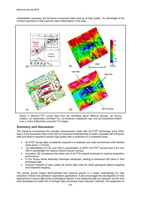
Figure 5. Marine-FTG ® survey data from the Nordkapp Basin offshore Norway. (a) Survey<br />
location, (b) bathymetry corrected Tzz, (c) lineament amplitude map, and (d) lineaments plotted<br />
over a colour bathymetry-corrected Tzz image.<br />
Summary and discussion<br />
The following summarises the principle achievements made with Air-FTG ® technology since 2004.<br />
Many of the successes have come from an increased understanding of what is possible with full tensor<br />
data and what is required to ensure high quality data is produced on a consistent basis.<br />
� Air-FTG ® survey data consistently acquired in a relatively low noise environment with residual<br />
noise levels < 7 Eo 2 km.<br />
� Tzz detectability of 2 Eo over 200 m wavelengths on BT67 Air-FTG ® surveys and 2 Eo over<br />
300 m wavelengths for Cessna Grand Caravan surveys.<br />
� Innovative QC procedures that make use of all FTG outputs employed to improve acquisition<br />
performance.<br />
� A Full Tensor Noise Reduction technique developed, leading to enhanced S/N ratios in final<br />
processed data.<br />
� Invariant Analysis of high quality full tensor data used for direct geological feature targeting<br />
and lineament mapping.<br />
The airship gravity project demonstrated that airborne gravity is a viable methodology for high<br />
resolution mineral and petroleum exploration applications. It also encouraged the development of new<br />
approaches to ensure high levels of geological signals in the measured data are captured, be this from<br />
tools developed for better QC or through data processing noise reduction methods. The application of<br />
150


