

Airborne Gravity 2010 - Geoscience Australia
Airborne Gravity 2010 - Geoscience Australia
Airborne Gravity 2010 - Geoscience Australia

Create successful ePaper yourself
Turn your PDF publications into a flip-book with our unique Google optimized e-Paper software.
<strong>Airborne</strong> <strong>Gravity</strong> <strong>2010</strong><br />
management issues (Figure 2). The work is also identifying significant limitations in current product<br />
and processing standards. Significant gaps still remain in bathymetry, and our ability to integrate data<br />
is still limited by the <strong>Australia</strong>n Height Datum and general lack of awareness of issues such as timevariant<br />
gravitationally-defined geoids. Current work on product specifications and standards is directed<br />
towards improving the current and future utility of the data.<br />
(a)<br />
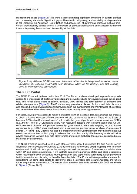
Figure 2. (a) <strong>Airborne</strong> LiDAR data over Narabeen, NSW, that is being used to model coastal<br />
inundation. (b) <strong>Airborne</strong> LiDAR data near Menindee, NSW, on the Darling River that is being<br />
used for water resource assessment.<br />
The NEDF Portal<br />
The NEDF Portal will be launched in late <strong>2010</strong>. The Portal has been developed to provide easy web<br />
access to a wide range of digital elevation data and derived products for government and public good<br />
use. The Portal allows users to search, discover, view, license and take delivery of elevation and<br />
related data products (Figure 3). The Portal not only provides a platform for improved data discovery<br />
and access, but has driven significant improvements in the management and maintenance of elevation<br />
and related data within <strong>Geoscience</strong> <strong>Australia</strong> and more broadly across government.<br />
For users, it will provide access to million’s of dollars worth of elevation data. Streamlining the process<br />
to obtain a licence to access different data sets will also be welcomed by users. There will be 3 tiers of<br />
licences. A “Creative Commons Licence” will provide the general public with access to national DEM’s<br />
(e.g., the SRTM 3” or 9” DEMs) and to any high resolution datasets with full distribution rights. An “Allof-Government<br />
Licence” will provide access by government to data sets requiring a data licence<br />
agreement (e.g., LiDAR data purchased from a commercial provider under a whole of government<br />
licence). A “Third Party Licence” will also be offered where the Commonwealth may hold the data but<br />
needs permission from a third party to release the data. Importantly this licensing model will allow<br />
private companies to make their data discoverable and ensure that data does not get purchased more<br />
than once by government.<br />
The NEDF Portal is intended to be a one stop elevation shop. It represents the first ArcGIS server<br />
application within <strong>Geoscience</strong> <strong>Australia</strong> (GA) delivering the functionality of GIS mapping tools in a web<br />
environment. It will help to improve the management and maintenance of elevation and related data<br />
within GA and across government. It will facilitate data sharing amongst states and other jurisdictions<br />
whilst reducing the costs associated with duplication of data capture and purchasing. It also provides a<br />
facility to monitor who is using or benefits from the data. The Portal will also provides a means for<br />
undertaking on-going data audits to identifying gaps in elevation data around <strong>Australia</strong> and where<br />
future acquisitions should occur. The results of an elevation data audit carried out in 2009 are shown<br />
in Figure 4 (Tickle, <strong>2010</strong>).<br />
(b)<br />
185


