

Airborne Gravity 2010 - Geoscience Australia
Airborne Gravity 2010 - Geoscience Australia
Airborne Gravity 2010 - Geoscience Australia

You also want an ePaper? Increase the reach of your titles
YUMPU automatically turns print PDFs into web optimized ePapers that Google loves.
<strong>Airborne</strong> <strong>Gravity</strong> <strong>2010</strong><br />
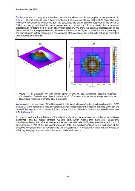
To illustrate the accuracy of the method, we use the Gaussian hill topography model presented in<br />
Figure 1. The hill extends from a base elevation of 0 m to an elevation of 300 m at its peak. The total<br />
number of observations locations is 625. We calculated the gravity gradient response of this terrain at<br />
350 m above ground level for each component and allowed a 1 E error. Note that a separate<br />
discretisation is determined for each observation location. We show the adaptive discretization of the<br />
Gaussian hill for a single observation location in the bottom of Figure 1. Note that the asymmetry of<br />
the discretisation in this instance is a consequence of the centre of the initial cells not being coincident<br />
with the peak of the model.<br />
(a)<br />
Figure 1. (a) Gaussian hill with height equal to 300 m. (b) Automated adaptive quadtree<br />
discretization of terrain to achieve a maximum of 1 E accuracy for all tensor components for an<br />
observation made 50 m directly above the peak.<br />
We compared the response of the Gaussian hill calculated with an adaptive quadtree-discretized DEM<br />
(Figure 2) to the result for a regularly-gridded, surface-based forward modelling scheme. Although we<br />
allowed the algorithm as much as 1 E error, the maximum difference between the two datasets was<br />
0.17 E (Figure 3).<br />
In order to evaluate the efficiency of the adaptive algorithm, we examine the number of calculations<br />
performed. The full model contains 729,088 cells, which means that there are 455,680,000<br />
calculations. Using the 1 E error level example, our method made 1,468,486 calculations, which is 310<br />
times less (or 0.3%) of the full model calculation total. An overhead related to the evaluation of the<br />
threshold conditions must be factored into this assessment. It is important to note that the degree of<br />
efficiency is highly dependent upon the terrain and data locations.<br />
133<br />
(b)


