

Airborne Gravity 2010 - Geoscience Australia
Airborne Gravity 2010 - Geoscience Australia
Airborne Gravity 2010 - Geoscience Australia

Create successful ePaper yourself
Turn your PDF publications into a flip-book with our unique Google optimized e-Paper software.
<strong>Airborne</strong> <strong>Gravity</strong> <strong>2010</strong><br />
domain. A constraint of this type can be used even when the actual relationships between the two<br />
properties are likely to be complicated and are unknown a priori (Lelièvre and Oldenburg, 2009;<br />
Lelièvre et al., 2009).<br />
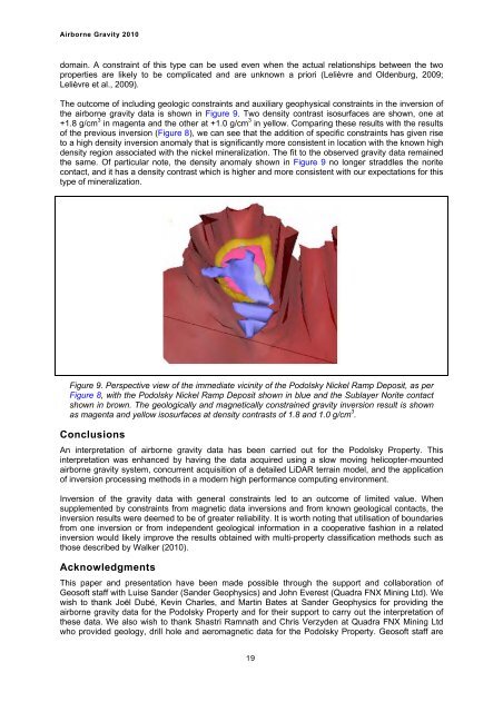
The outcome of including geologic constraints and auxiliary geophysical constraints in the inversion of<br />
the airborne gravity data is shown in Figure 9. Two density contrast isosurfaces are shown, one at<br />
+1.8 g/cm 3 in magenta and the other at +1.0 g/cm 3 in yellow. Comparing these results with the results<br />
of the previous inversion (Figure 8), we can see that the addition of specific constraints has given rise<br />
to a high density inversion anomaly that is significantly more consistent in location with the known high<br />
density region associated with the nickel mineralization. The fit to the observed gravity data remained<br />
the same. Of particular note, the density anomaly shown in Figure 9 no longer straddles the norite<br />
contact, and it has a density contrast which is higher and more consistent with our expectations for this<br />
type of mineralization.<br />
Figure 9. Perspective view of the immediate vicinity of the Podolsky Nickel Ramp Deposit, as per<br />
Figure 8, with the Podolsky Nickel Ramp Deposit shown in blue and the Sublayer Norite contact<br />
shown in brown. The geologically and magnetically constrained gravity inversion result is shown<br />
as magenta and yellow isosurfaces at density contrasts of 1.8 and 1.0 g/cm 3 .<br />
Conclusions<br />
An interpretation of airborne gravity data has been carried out for the Podolsky Property. This<br />
interpretation was enhanced by having the data acquired using a slow moving helicopter-mounted<br />
airborne gravity system, concurrent acquisition of a detailed LiDAR terrain model, and the application<br />
of inversion processing methods in a modern high performance computing environment.<br />
Inversion of the gravity data with general constraints led to an outcome of limited value. When<br />
supplemented by constraints from magnetic data inversions and from known geological contacts, the<br />
inversion results were deemed to be of greater reliability. It is worth noting that utilisation of boundaries<br />
from one inversion or from independent geological information in a cooperative fashion in a related<br />
inversion would likely improve the results obtained with multi-property classification methods such as<br />
those described by Walker (<strong>2010</strong>).<br />
Acknowledgments<br />
This paper and presentation have been made possible through the support and collaboration of<br />
Geosoft staff with Luise Sander (Sander Geophysics) and John Everest (Quadra FNX Mining Ltd). We<br />
wish to thank Joël Dubé, Kevin Charles, and Martin Bates at Sander Geophysics for providing the<br />
airborne gravity data for the Podolsky Property and for their support to carry out the interpretation of<br />
these data. We also wish to thank Shastri Ramnath and Chris Verzyden at Quadra FNX Mining Ltd<br />
who provided geology, drill hole and aeromagnetic data for the Podolsky Property. Geosoft staff are<br />
19


