

Airborne Gravity 2010 - Geoscience Australia
Airborne Gravity 2010 - Geoscience Australia
Airborne Gravity 2010 - Geoscience Australia

Create successful ePaper yourself
Turn your PDF publications into a flip-book with our unique Google optimized e-Paper software.
<strong>Airborne</strong> <strong>Gravity</strong> <strong>2010</strong><br />
� improving velocity models in terms of density models;<br />
� mapping in fold/thrust belt terranes;<br />
� detecting salt domes, carbonate platforms and pinnacle reefs, and<br />
� assisting in mapping of the base of salt and salt geometry.<br />
AirG and AGG gravity technologies are both useful in these applications, with the prime differentiator<br />
being the wavelength of interest. AirG is generally used for applications requiring longer wavelengths.<br />
Routine conforming of FALCON gravity to regional fields has made this distinction from AGG less<br />
critical (Dransfield, <strong>2010</strong>).<br />
The most common application for gravity in oil and gas explorations remains basement mapping.<br />
Fernandez et al. (2009) describe an application using the FALCON AGG in an area near Chirete in<br />
Argentina, and the example in the next section describes the use of the GT-1A system in Ghana.<br />
3D inversions and interpretation – the Volta Basin study<br />
Interpretation of potential field data has made increasing use of 3D inversion technology over the last<br />
decade and it is increasingly common for 3D geological models to be developed from AGG data (see<br />
for example, Nicholls et al., 2007) and AirG data. The Volta Basin study is based on airborne gravity<br />
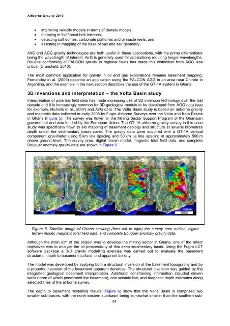
and magnetic data collected in early 2008 by Fugro <strong>Airborne</strong> Surveys over the Volta and Keta Basins<br />
in Ghana (Figure 5). The survey was flown for the Mining Sector Support Program of the Ghanaian<br />
government and was funded by the European Union. The GT-1A airborne gravity survey in this case<br />
study was specifically flown to aid mapping of basement geology and structure at several kilometres<br />
depth under the sedimentary basin cover. The gravity data were acquired with a GT-1A vertical<br />
component gravimeter using 5 km line spacing and 50 km tie line spacing at approximately 500 m<br />
above ground level. The survey area, digital terrain model, magnetic total field data, and complete<br />
Bouguer anomaly gravity data are shown in Figure 5.<br />
Figure 5. Satellite image of Ghana showing (from left to right) the survey area outline, digital<br />
terrain model, magnetic total field data, and complete Bouguer anomaly gravity data.<br />
Although the main aim of the project was to develop the mining sector in Ghana, one of the minor<br />
objectives was to analyse the oil prospectivity of this deep sedimentary basin. Using the Fugro LCT<br />
software package a 3-D gravity modelling exercise was carried out to evaluate the basement<br />
structures, depth to basement surface, and apparent density.<br />
The model was developed by applying both a structural inversion of the basement topography and by<br />
a property inversion of the basement apparent densities. The structural inversion was guided by the<br />
integrated geological basement interpretation. Additional constraining information included eleven<br />
wells (three of which penetrated the basement), one seismic line, and magnetic depth estimates along<br />
selected lines of the airborne survey.<br />
The depth to basement modelling results (Figure 6) show that the Volta Basin is comprised two<br />
smaller sub-basins, with the north eastern sub-basin being somewhat smaller than the southern sub-<br />
54<br />
250km


