

Airborne Gravity 2010 - Geoscience Australia
Airborne Gravity 2010 - Geoscience Australia
Airborne Gravity 2010 - Geoscience Australia

Create successful ePaper yourself
Turn your PDF publications into a flip-book with our unique Google optimized e-Paper software.
<strong>Airborne</strong> <strong>Gravity</strong> <strong>2010</strong><br />
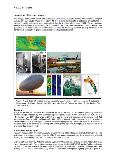
Images on the front cover<br />
The images on the cover of this joint publication <strong>Geoscience</strong> <strong>Australia</strong> Record <strong>2010</strong>/23 and Geological<br />
Survey of New South Wales File GS<strong>2010</strong>/0457 (Figure 1) illustrate a selection of highlights for<br />
airborne gravity technology and applications that have taken place since 2004. These highlights<br />
include the adaptation of existing technologies to produce new acquisition configurations, new<br />
generations of instruments, and application of airborne (including satellite) gravity methods at all<br />
conceivable scales; from global, through regional, to prospect scales.<br />
Figure 1. Montage of images and photographs used on the front cover of joint publication<br />
<strong>Geoscience</strong> <strong>Australia</strong> Record <strong>2010</strong>/23 and Geological Survey of New South Wales File<br />
GS<strong>2010</strong>/0457.<br />
Top row<br />
Image of the first global geoid model based on data from the GOCE satellite gravity gradiometer<br />
system. Image released by the European Space Agency (ESA) in mid-<strong>2010</strong> (GOCE, n.d.). GOCE<br />
(Drinkwater et al., 2007), launched in 2009, provides global gravity gradiometer information with 100<br />
km resolution from an orbit at altitudes of 250 to 300 km. Complete global coverage is achieved on a<br />
61-day repeat cycle, enabling estimates of the time-varying gravity field to be recorded in addition to<br />
the production of an estimate of the long-term mean gravity field that will improve in accuracy as more<br />
and more data are acquired.<br />
Middle row, left to right<br />
Recently released GT-2A airborne gravity system inside a BN-2T Islander aircraft (Olson, <strong>2010</strong>). This<br />
instrument is a major upgrade from the GT-1A instrument launched into the marketplace in 2003.<br />
Photograph supplied by Dan Olson, Canadian Micro <strong>Gravity</strong> Ltd.<br />
Micro-g LaCoste Turnkey <strong>Airborne</strong> <strong>Gravity</strong> System (TAGS) airborne gravity system installed in a US<br />
Navy King Air aircraft. This photograph was taken during the 2009 GRAV-D Alaska-Fairbanks Survey<br />
carried out by the National Oceanic and Atmospheric Administration (NOAA) National Geodetic<br />
Survey (NGS). The survey, funded by National Geospatial Intelligence Agency (NGA), is part of a<br />
2


