

Airborne Gravity 2010 - Geoscience Australia
Airborne Gravity 2010 - Geoscience Australia
Airborne Gravity 2010 - Geoscience Australia

You also want an ePaper? Increase the reach of your titles
YUMPU automatically turns print PDFs into web optimized ePapers that Google loves.
<strong>Airborne</strong> <strong>Gravity</strong> <strong>2010</strong><br />
<strong>Gravity</strong> inversions<br />
It has become possible with improvements to computer performance and software to routinely model<br />
gravity data using inversion methods. However, it is well known that gravity inversion is an ill-posed<br />
problem, and that any derived density model is non-unique. Therefore, after completing the preprocessing<br />
of the airborne gravity data, the real challenge in gravity inversion is not just to find a model<br />
which has a predicted gravity response in agreement with the observed data, but to find such a model<br />
which is consistent with other geophysical and geological constraints. In this section, we present the<br />
results of an inversion using very general constraints, and follow this up with the results of an inversion<br />
that incorporated the knowledge obtained from interpretation of the airborne magnetic data and a priori<br />
geological knowledge of the region.<br />
<strong>Gravity</strong> inversion with general constraints<br />
As a benchmark, an inversion with general constraints was performed using the methodology and<br />
software described by Li and Oldenburg (1998). The software has been tailored to operate in a multiprocessor/multi-core<br />
environment, the details of which will be presented in a subsequent publication.<br />
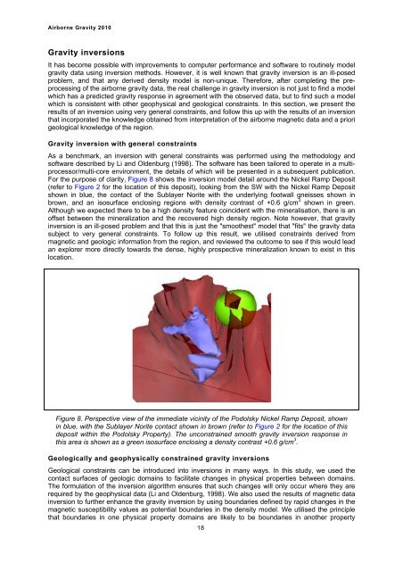
For the purpose of clarity, Figure 8 shows the inversion model detail around the Nickel Ramp Deposit<br />
(refer to Figure 2 for the location of this deposit), looking from the SW with the Nickel Ramp Deposit<br />
shown in blue, the contact of the Sublayer Norite with the underlying footwall gneisses shown in<br />
brown, and an isosurface enclosing regions with density contrast of +0.6 g/cm 3 shown in green.<br />
Although we expected there to be a high density feature coincident with the mineralisation, there is an<br />
offset between the mineralization and the recovered high density region. Note however, that gravity<br />
inversion is an ill-posed problem and that this is just the "smoothest" model that "fits" the gravity data<br />
subject to very general constraints. To follow up this result, we utilised constraints derived from<br />
magnetic and geologic information from the region, and reviewed the outcome to see if this would lead<br />
an explorer more directly towards the dense, highly prospective mineralization known to exist in this<br />
location.<br />
Figure 8. Perspective view of the immediate vicinity of the Podolsky Nickel Ramp Deposit, shown<br />
in blue, with the Sublayer Norite contact shown in brown (refer to Figure 2 for the location of this<br />
deposit within the Podolsky Property). The unconstrained smooth gravity inversion response in<br />
this area is shown as a green isosurface enclosing a density contrast +0.6 g/cm 3 .<br />
Geologically and geophysically constrained gravity inversions<br />
Geological constraints can be introduced into inversions in many ways. In this study, we used the<br />
contact surfaces of geologic domains to facilitate changes in physical properties between domains.<br />
The formulation of the inversion algorithm ensures that such changes will only occur where they are<br />
required by the geophysical data (Li and Oldenburg, 1998). We also used the results of magnetic data<br />
inversion to further enhance the gravity inversion by using boundaries defined by rapid changes in the<br />
magnetic susceptibility values as potential boundaries in the density model. We utilised the principle<br />
that boundaries in one physical property domains are likely to be boundaries in another property<br />
18


