

Airborne Gravity 2010 - Geoscience Australia
Airborne Gravity 2010 - Geoscience Australia
Airborne Gravity 2010 - Geoscience Australia

You also want an ePaper? Increase the reach of your titles
YUMPU automatically turns print PDFs into web optimized ePapers that Google loves.
<strong>Airborne</strong> <strong>Gravity</strong> <strong>2010</strong><br />
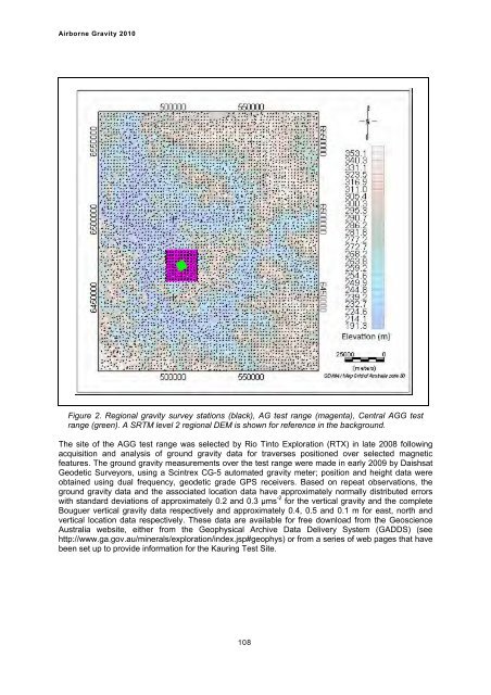
Figure 2. Regional gravity survey stations (black), AG test range (magenta), Central AGG test<br />
range (green). A SRTM level 2 regional DEM is shown for reference in the background.<br />
The site of the AGG test range was selected by Rio Tinto Exploration (RTX) in late 2008 following<br />
acquisition and analysis of ground gravity data for traverses positioned over selected magnetic<br />
features. The ground gravity measurements over the test range were made in early 2009 by Daishsat<br />
Geodetic Surveyors, using a Scintrex CG-5 automated gravity meter; position and height data were<br />
obtained using dual frequency, geodetic grade GPS receivers. Based on repeat observations, the<br />
ground gravity data and the associated location data have approximately normally distributed errors<br />
with standard deviations of approximately 0.2 and 0.3 µms -2 for the vertical gravity and the complete<br />
Bouguer vertical gravity data respectively and approximately 0.4, 0.5 and 0.1 m for east, north and<br />
vertical location data respectively. These data are available for free download from the <strong>Geoscience</strong><br />
<strong>Australia</strong> website, either from the Geophysical Archive Data Delivery System (GADDS) (see<br />
http://www.ga.gov.au/minerals/exploration/index.jsp#geophys) or from a series of web pages that have<br />
been set up to provide information for the Kauring Test Site.<br />
108


