

Airborne Gravity 2010 - Geoscience Australia
Airborne Gravity 2010 - Geoscience Australia
Airborne Gravity 2010 - Geoscience Australia

You also want an ePaper? Increase the reach of your titles
YUMPU automatically turns print PDFs into web optimized ePapers that Google loves.
<strong>Airborne</strong> <strong>Gravity</strong>, <strong>2010</strong><br />
Reigber, 1989), but some of these global models use additional terrestrial gravimetry from a variety of<br />
sensors, including gravity anomalies derived from satellite radar altimetry and a limited amount of<br />
airborne gravimetry. Broadly, these can be classified between satellite-only and combined global<br />
geopotential models.<br />
More recently, the CHAMP (Challenging Mini Satellite Payload; Reigber et al., 1999), GRACE (<strong>Gravity</strong><br />
Recovery and Climate Experiment; Tapley et al., 2004) and GOCE (<strong>Gravity</strong> field and steady-state<br />
Ocean Circulation Explorer; Drinkwater et al., 2003; Johannessen et al., 2003) satellite missions have<br />
significantly enhanced the long-wavelength determination of the gravity field (cf. Balmino et al., 1999).<br />
However, because of attenuation of the gravitational signal with altitude, satellite-only models are<br />
always of long wavelength in nature. The short wavelengths can be supplemented by terrestrial gravity<br />
data (land, marine, altimeter, airborne), but only where it is available.<br />
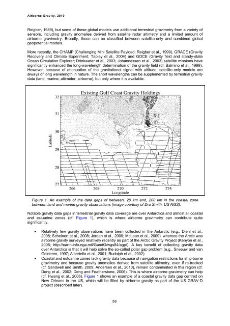
Figure 1. An example of the data gaps of between, 20 km and, 200 km in the coastal zone<br />
between land and marine gravity observations (image courtesy of Dru Smith, US NGS).<br />
Notable gravity data gaps in terrestrial gravity data coverage are over Antarctica and almost all coastal<br />
and estuarine zones (cf. Figure 1), which is where airborne gravimetry can contribute quite<br />
significantly.<br />
� Relatively few gravity observations have been collected in the Antarctic (e.g., Diehl et al.,<br />
2008; Scheinert et al., 2008; Jordan et al., 2009; McLean et al., 2009), whereas the Arctic was<br />
airborne gravity surveyed relatively recently as part of the Arctic <strong>Gravity</strong> Project (Kenyon et al.,<br />
2008; http://earth-info.nga.mil/GandG/wgs84/agp/). A key benefit of collecting gravity data<br />
over Antarctica is that it will help solve the so-called polar gap problem (e.g., Sneeuw and van<br />
Gelderen, 1997; Albertella et al., 2001; Rudolph et al., 2002).<br />
� Coastal and estuarine zones lack gravity data because of navigation restrictions for ship-borne<br />
gravimetry and because gravity anomalies derived from satellite altimetry, even if re-tracked<br />
(cf. Sandwell and Smith, 2009; Andersen et al., <strong>2010</strong>), remain contaminated in this region (cf.<br />
Deng et al., 2002; Deng and Featherstone, 2006). This is where airborne gravimetry can help<br />
(cf. Hwang et al., 2006). Figure 1 shows an example of a coastal gravity data gap centred on<br />
New Orleans in the US, which will be filled by airborne gravity as part of the US GRAV-D<br />
project (described later).<br />
59


