

Airborne Gravity 2010 - Geoscience Australia
Airborne Gravity 2010 - Geoscience Australia
Airborne Gravity 2010 - Geoscience Australia

You also want an ePaper? Increase the reach of your titles
YUMPU automatically turns print PDFs into web optimized ePapers that Google loves.
<strong>Airborne</strong> <strong>Gravity</strong>, <strong>2010</strong><br />
Modern satellite gravimetry<br />
At the broadest conceptual level, dedicated satellite gravimetry missions observe (either directly or<br />
indirectly) the Earth’s external gravitational gradients. This is essentially through differential<br />
measurements between two (or more) points, thus largely eliminating correlated errors. This can take<br />
two approaches (e.g., Rummel, 1979, 1986; Rummel et al., 1999; Jekeli, 1999; Rummel et al., 2002):<br />
satellite-to-satellite tracking (SST) or a dedicated gravity gradiometer instrument onboard a satellite.<br />
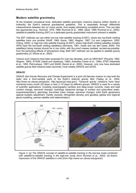
The SST methods can use either low-low inter-satellite tracking (ll-SST), where two low-Earth orbiting<br />
satellites track one another (Wolff, 1969; Kaula, 1983; Wagner, 1987; Cui and Lelgemann, 2000;<br />
Cheng, 2002), or high-low inter-satellite tracking (hl-SST), where high-Earth orbiting satellites (notably<br />
GPS) track the low-Earth orbiting satellite(s) (Schrama, 1991; Visser and van den IJssel, 2000). The<br />
satellite(s) being tracked should be in low orbits, with the proof masses isolated, as-best-as-possible,<br />
from the perturbing effects of atmospheric drag. Both SST methods can be applied to satellite gravity<br />
gradiometry (cf. Ditmar et al., 2003).<br />
Various such missions have been proposed for over two decades, such as GRAVSAT (Piscane, 1982;<br />
Wagner, 1983), STAGE (Jekeli and Upadhyay, 1990), Aristotles (Visser et al., 1994), STEP (Albertella<br />
et al., 1995; Petrovskaya, 1997) and SAGE (Sansò et al., 2000). However, only now have dedicated<br />
satellite gravity field missions been launched, most notably GRACE and GOCE.<br />
GRACE<br />
GRACE (the <strong>Gravity</strong> Recovery and Climate Experiment) is a joint US-German mission to map both the<br />
static and a time-variable parts of the Earth’s external gravity field (Tapley et al., 2004;<br />
http://www.csr.utexas.edu/grace/; http://grace.jpl.nasa.gov/). Temporal gravity variations have been<br />
monitored every month (30 days) or less (1-10 days) by different groups. GRACE is used for a variety<br />
of scientific applications, including oceanography (surface and deep-ocean currents, mass and heat<br />
content change, sea-level change); hydrology (seasonal storage of surface and subsurface water,<br />
evapotranspiration); glaciology (ice-sheet mass change, sea-level change); solid Earth geophysics<br />
(glacial isostatic adjustment, mantle viscosity, lithosphere density) and geodesy (global and regional<br />
geoid modelling, precise satellite orbit determination).<br />
(a)<br />
Figure 2. (a) The GRACE concept of satellite-to-satellite tracking in the low-low mode combined<br />
with satellite-to-satellite tracking in the high-low mode (from Rummel et al., 2002). (b) Artist’s<br />
impression of the GRACE satellites in orbit (from http://www.csr.utexas.edu/grace/).<br />
60<br />
(b)


