

Airborne Gravity 2010 - Geoscience Australia
Airborne Gravity 2010 - Geoscience Australia
Airborne Gravity 2010 - Geoscience Australia

Create successful ePaper yourself
Turn your PDF publications into a flip-book with our unique Google optimized e-Paper software.
<strong>Airborne</strong> <strong>Gravity</strong> <strong>2010</strong><br />
Case studies<br />
There are many case studies in which airborne gravity has played an important part in helping create a<br />
coherent 3D geological model to help delineate economic resources. GeoModeller is revolutionizing<br />
the ability to create a 3D structural geology interpretation quickly and then have this tested using<br />
independently collected gravity data.<br />
The first of two cases mentioned here is from Uganda and the recent near-surface oil that is<br />
associated with Lake Victoria. The horst and graben controls are readily seen in the initial FTG data.<br />
Utilising an initial 3D geological interpretation to produce a forward prediction of the gravitational<br />
response, we see a misfit with the observed FTG data. An iterative refinement of the 3D geology<br />
model is carried out until a primary reconciliation of both the geological constraints underpinning the<br />
3D geological interpretation and the observed FTG data is achieved.<br />
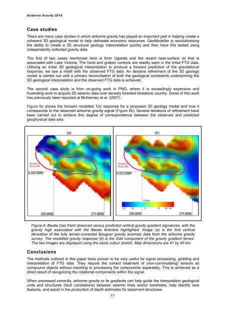
The second case study is from on-going work in PNG, where it is exceedingly expensive and<br />
frustrating work to acquire 2D seismic data over densely forested limestone country. Some of this work<br />
has previously been reported at McInerney et al. (2007).<br />
Figure 6a shows the forward modelled Tzz response for a proposed 3D geology model and how it<br />
corresponds to the observed airborne gravity signal (Figure 6b). Several iterations of refinement have<br />
been carried out to achieve this degree of correspondence between the observed and predicted<br />
geophysical data sets.<br />
(a)<br />
Figure 6. Bwata Gas Field observed versus predicted vertical gravity gradient signatures, with the<br />
gravity high associated with the Bwata Anticline highlighted. Image (a) is the first vertical<br />
derivative of the fully terrain-corrected Bouguer gravity anomaly data from the airborne gravity<br />
survey. The modelled gravity response (b) is the Gdd component of the gravity gradient tensor.<br />
The two images are displayed using the same colour stretch. Map dimensions are 41 by 40 km.<br />
Conclusions<br />
The methods outlined in this paper have proven to be very useful for signal processing, gridding and<br />
interpretation of FTG data. They require the correct treatment of (non-commutating) tensors as<br />
compound objects without resorting to processing the components separately. This is achieved as a<br />
direct result of recognizing the rotational components within the signal.<br />
When processed correctly, airborne gravity or its gradients can help guide the interpolation geological<br />
units and structures (fault correlations) between seismic lines and/or boreholes, help identify new<br />
features, and assist in the production of depth estimates for basement structures.<br />
77<br />
(b)


