

Airborne Gravity 2010 - Geoscience Australia
Airborne Gravity 2010 - Geoscience Australia
Airborne Gravity 2010 - Geoscience Australia

Create successful ePaper yourself
Turn your PDF publications into a flip-book with our unique Google optimized e-Paper software.
<strong>Airborne</strong> <strong>Gravity</strong> <strong>2010</strong><br />
triangulated polyhedrons. Interoperability with widely used commercial software such as GOCAD,<br />
GeoModeller (Intrepid), Oasis Montaj (Geosoft), and GMSys (Geosoft) is a key feature of IGMAS+.<br />
Lahmeyer et al. (<strong>2010</strong>) illustrate this point by describing a modelling workflow that is used at Statoil.<br />
Users construct realistic geological models using interactive model editing tools. Inversion of<br />
geophysical data is carried out in the 3D geological model environment to obtain various model<br />
parameters (e.g., geometry, density, susceptibility, and magnetization). The geological foundations of<br />
IGMAS+ are important since geological constraints play a critical role in the minimisation of the<br />
ambiguities that are inherent in gravity and magnetic modelling.<br />
When a geometry change is made using the modelling interface, the user can update the gravity effect<br />
(and/or the tensor components) of a model very quickly because it is only that part of the response<br />
that is related to the changed triangles that needs to be re-calculated. Optimized storage structures<br />
enable density inversion to be performed very rapidly.<br />
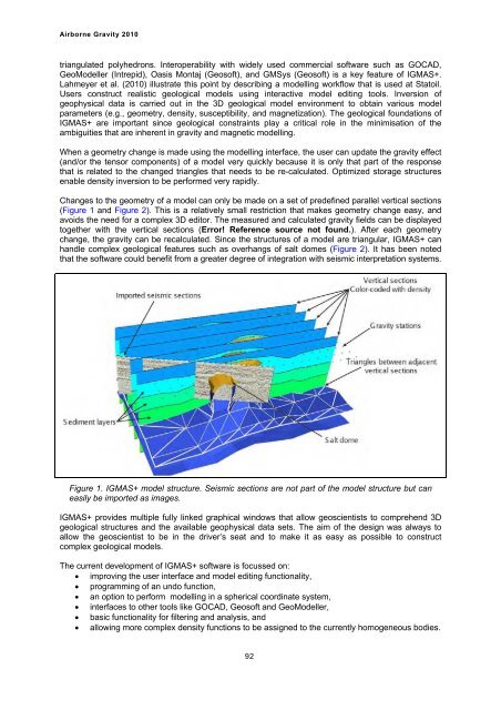
Changes to the geometry of a model can only be made on a set of predefined parallel vertical sections<br />
(Figure 1 and Figure 2). This is a relatively small restriction that makes geometry change easy, and<br />
avoids the need for a complex 3D editor. The measured and calculated gravity fields can be displayed<br />
together with the vertical sections (Error! Reference source not found.). After each geometry<br />
change, the gravity can be recalculated. Since the structures of a model are triangular, IGMAS+ can<br />
handle complex geological features such as overhangs of salt domes (Figure 2). It has been noted<br />
that the software could benefit from a greater degree of integration with seismic interpretation systems.<br />
Figure 1. IGMAS+ model structure. Seismic sections are not part of the model structure but can<br />
easily be imported as images.<br />
IGMAS+ provides multiple fully linked graphical windows that allow geoscientists to comprehend 3D<br />
geological structures and the available geophysical data sets. The aim of the design was always to<br />
allow the geoscientist to be in the driver’s seat and to make it as easy as possible to construct<br />
complex geological models.<br />
The current development of IGMAS+ software is focussed on:<br />
� improving the user interface and model editing functionality,<br />
� programming of an undo function,<br />
� an option to perform modelling in a spherical coordinate system,<br />
� interfaces to other tools like GOCAD, Geosoft and GeoModeller,<br />
� basic functionality for filtering and analysis, and<br />
� allowing more complex density functions to be assigned to the currently homogeneous bodies.<br />
92


