

Airborne Gravity 2010 - Geoscience Australia
Airborne Gravity 2010 - Geoscience Australia
Airborne Gravity 2010 - Geoscience Australia

You also want an ePaper? Increase the reach of your titles
YUMPU automatically turns print PDFs into web optimized ePapers that Google loves.
<strong>Airborne</strong> <strong>Gravity</strong> <strong>2010</strong><br />
New methods, specific to satellite gravity data, are required, for example, for computing Bouguer<br />
anomalies. Furthermore, in ice-covered areas, no terrain corrections have so far been applied and the<br />
computed anomalies do not take into account for the reduced density associated with ice sheets.<br />
Satellite gravity data resolution and lithospheric studies<br />
The resolving power of satellite gravity is an issue that needs to be addressed and must be quantified<br />
to ascertain the degree to which the satellite data resolves lithospheric structures. This can be<br />
achieved by comparing the satellite data to gravity and gradients predicted from existing 3D density<br />
models (Figure 1). Another test of the resolution of satellite-derived data is to compare it with the<br />
gravity field predicted from independently determined density models based on petrological and<br />
thermodynamic approaches.<br />
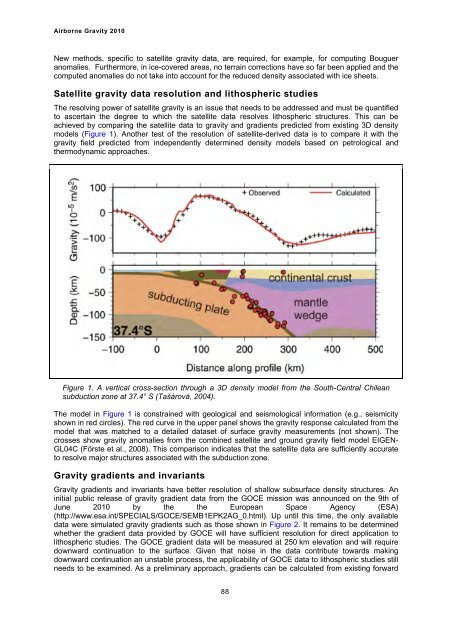
Figure 1. A vertical cross-section through a 3D density model from the South-Central Chilean<br />
subduction zone at 37.4° S (Tašárová, 2004).<br />
The model in Figure 1 is constrained with geological and seismological information (e.g., seismicity<br />
shown in red circles). The red curve in the upper panel shows the gravity response calculated from the<br />
model that was matched to a detailed dataset of surface gravity measurements (not shown). The<br />
crosses show gravity anomalies from the combined satellite and ground gravity field model EIGEN-<br />
GL04C (Förste et al., 2008). This comparison indicates that the satellite data are sufficiently accurate<br />
to resolve major structures associated with the subduction zone.<br />
<strong>Gravity</strong> gradients and invariants<br />
<strong>Gravity</strong> gradients and invariants have better resolution of shallow subsurface density structures. An<br />
initial public release of gravity gradient data from the GOCE mission was announced on the 9th of<br />
June <strong>2010</strong> by the the European Space Agency (ESA)<br />
(http://www.esa.int/SPECIALS/GOCE/SEMB1EPK2AG_0.html). Up until this time, the only available<br />
data were simulated gravity gradients such as those shown in Figure 2. It remains to be determined<br />
whether the gradient data provided by GOCE will have sufficient resolution for direct application to<br />
lithospheric studies. The GOCE gradient data will be measured at 250 km elevation and will require<br />
downward continuation to the surface. Given that noise in the data contribute towards making<br />
downward continuation an unstable process, the applicability of GOCE data to lithospheric studies still<br />
needs to be examined. As a preliminary approach, gradients can be calculated from existing forward<br />
88


