

Airborne Gravity 2010 - Geoscience Australia
Airborne Gravity 2010 - Geoscience Australia
Airborne Gravity 2010 - Geoscience Australia

Create successful ePaper yourself
Turn your PDF publications into a flip-book with our unique Google optimized e-Paper software.
<strong>Airborne</strong> <strong>Gravity</strong> <strong>2010</strong><br />
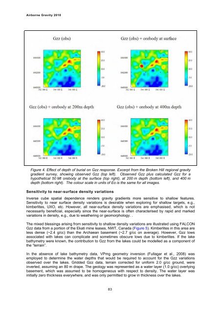
Figure 4. Effect of depth of burial on Gzz response. Excerpt from the Broken Hill regional gravity<br />
gradient survey, showing observed Gzz (top left). Observed Gzz plus calculated Gzz for a<br />
hypothetical 50 Mt orebody at the surface (top right), at 200 m depth (bottom left), and 400 m<br />
depth (bottom right). The colour scale in units of Eo is the same for all images.<br />
Sensitivity to near-surface density variations<br />
Inverse cube spatial dependence renders gravity gradients more sensitive to shallow features.<br />
Sensitivity to near surface density variations is desirable when exploring for shallow targets, e.g.,<br />
kimberlites, UXO, etc. However, all near-surface density variations are emphasised, which is not<br />
necessarily beneficial, especially since the near-surface is often characterised by rapid and marked<br />
variations in density, e.g., due to weathering or geomorphology. .<br />
The mixed blessings arising from sensitivity to shallow density variations are illustrated using FALCON<br />
Gzz data from a portion of the Ekati mine leases, NWT, Canada (Figure 5). Kimberlites in this area are<br />
less dense (~2.4 g/cc) than the Archaean basement (~2.7 g/cc on average). However, Gzz lows<br />
associated with lakes can complicate and sometimes obscure lows due to kimberlites. If the lake<br />
bathymetry were known, the contribution to Gzz from the lakes could be modelled as a component of<br />
the “terrain”.<br />
In the absence of lake bathymetry data, VPmg geometry inversion (Fullagar et al., 2008) was<br />
employed to determine the water depths that would be required to account for the Gzz variations<br />
observed over the lakes. Gridded Gzz data, terrain corrected for uniform 2.0 g/cc ground, were<br />
inverted, assuming an 80 m drape. The geology was represented as a water layer (1.0 g/cc) overlying<br />
basement, which was assumed to be homogeneous with respect to density. The water layer was<br />
initially zero thickness everywhere, and was only permitted to grow in thickness over the lakes.<br />
83


