

Airborne Gravity 2010 - Geoscience Australia
Airborne Gravity 2010 - Geoscience Australia
Airborne Gravity 2010 - Geoscience Australia

Create successful ePaper yourself
Turn your PDF publications into a flip-book with our unique Google optimized e-Paper software.
<strong>Airborne</strong> <strong>Gravity</strong> <strong>2010</strong><br />
It is envisaged that the Kauring test site will facilitate the comparison of AG and AGG data with ground<br />
gravity data (or products derived from these data) and will provide a benchmark for the comparison of<br />
different AG and AGG systems, as well as other airborne surveying methods including LiDAR and EM<br />
systems (Figure 7). As various test data sets become available for public distribution, they will<br />
constitute an increasingly valuable resource for developing and demonstrating data processing,<br />
modelling and interpretation methods for AG, AGG and other airborne geophysical data types.<br />
The Western <strong>Australia</strong>n government is proud to have been able to facilitate the establishment of what<br />
may be the first publicly accessible airborne gravity and gravity gradiometer test range in the world<br />
through its Exploration Incentive Scheme and in cooperation with industry (RTX) and the<br />
Commonwealth (GA). GSWA and GA encourage companies to perform system tests over the site and<br />
to submit their results for inclusion in the database.<br />
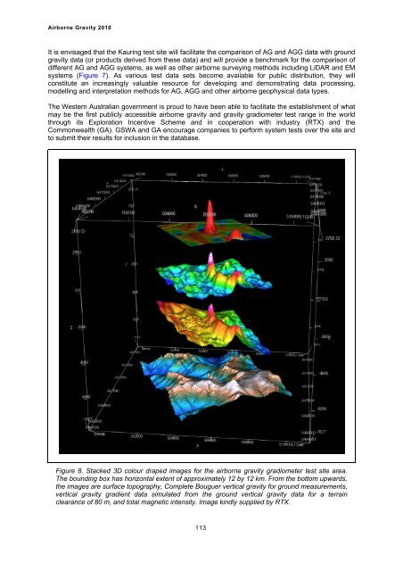
Figure 8. Stacked 3D colour draped images for the airborne gravity gradiometer test site area.<br />
The bounding box has horizontal extent of approximately 12 by 12 km. From the bottom upwards,<br />
the images are surface topography, Complete Bouguer vertical gravity for ground measurements,<br />
vertical gravity gradient data simulated from the ground vertical gravity data for a terrain<br />
clearance of 80 m, and total magnetic intensity. Image kindly supplied by RTX.<br />
113


