Four degrees and beyond: the potential for a global ... - Amper
Four degrees and beyond: the potential for a global ... - Amper
Four degrees and beyond: the potential for a global ... - Amper
You also want an ePaper? Increase the reach of your titles
YUMPU automatically turns print PDFs into web optimized ePapers that Google loves.
102 F. Fung et al.<br />
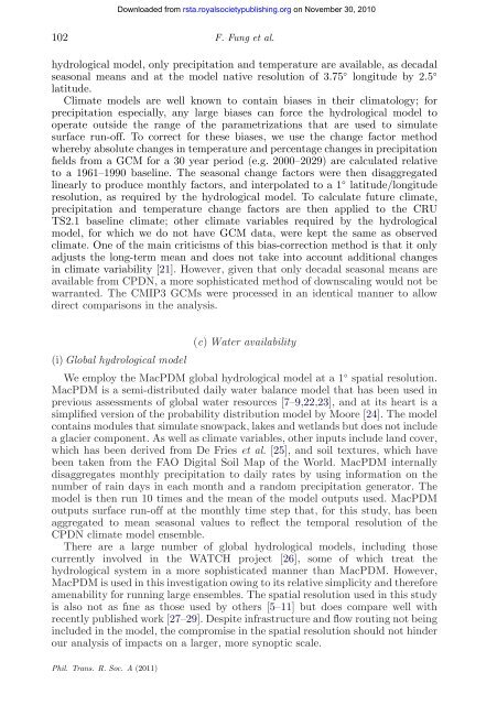
hydrological model, only precipitation <strong>and</strong> temperature are available, as decadal<br />
seasonal means <strong>and</strong> at <strong>the</strong> model native resolution of 3.75 ◦ longitude by 2.5 ◦<br />
latitude.<br />
Climate models are well known to contain biases in <strong>the</strong>ir climatology; <strong>for</strong><br />
precipitation especially, any large biases can <strong>for</strong>ce <strong>the</strong> hydrological model to<br />
operate outside <strong>the</strong> range of <strong>the</strong> parametrizations that are used to simulate<br />
surface run-off. To correct <strong>for</strong> <strong>the</strong>se biases, we use <strong>the</strong> change factor method<br />
whereby absolute changes in temperature <strong>and</strong> percentage changes in precipitation<br />
fields from a GCM <strong>for</strong> a 30 year period (e.g. 2000–2029) are calculated relative<br />
to a 1961–1990 baseline. The seasonal change factors were <strong>the</strong>n disaggregated<br />
linearly to produce monthly factors, <strong>and</strong> interpolated to a 1 ◦ latitude/longitude<br />
resolution, as required by <strong>the</strong> hydrological model. To calculate future climate,<br />
precipitation <strong>and</strong> temperature change factors are <strong>the</strong>n applied to <strong>the</strong> CRU<br />
TS2.1 baseline climate; o<strong>the</strong>r climate variables required by <strong>the</strong> hydrological<br />
model, <strong>for</strong> which we do not have GCM data, were kept <strong>the</strong> same as observed<br />
climate. One of <strong>the</strong> main criticisms of this bias-correction method is that it only<br />
adjusts <strong>the</strong> long-term mean <strong>and</strong> does not take into account additional changes<br />
in climate variability [21]. However, given that only decadal seasonal means are<br />
available from CPDN, a more sophisticated method of downscaling would not be<br />
warranted. The CMIP3 GCMs were processed in an identical manner to allow<br />
direct comparisons in <strong>the</strong> analysis.<br />
(c) Water availability<br />
(i) Global hydrological model<br />
We employ <strong>the</strong> MacPDM <strong>global</strong> hydrological model at a 1◦ spatial resolution.<br />
MacPDM is a semi-distributed daily water balance model that has been used in<br />
previous assessments of <strong>global</strong> water resources [7–9,22,23], <strong>and</strong> at its heart is a<br />
simplified version of <strong>the</strong> probability distribution model by Moore [24]. The model<br />
contains modules that simulate snowpack, lakes <strong>and</strong> wetl<strong>and</strong>s but does not include<br />
a glacier component. As well as climate variables, o<strong>the</strong>r inputs include l<strong>and</strong> cover,<br />
which has been derived from De Fries et al. [25], <strong>and</strong> soil textures, which have<br />
been taken from <strong>the</strong> FAO Digital Soil Map of <strong>the</strong> World. MacPDM internally<br />
disaggregates monthly precipitation to daily rates by using in<strong>for</strong>mation on <strong>the</strong><br />
number of rain days in each month <strong>and</strong> a r<strong>and</strong>om precipitation generator. The<br />
model is <strong>the</strong>n run 10 times <strong>and</strong> <strong>the</strong> mean of <strong>the</strong> model outputs used. MacPDM<br />
outputs surface run-off at <strong>the</strong> monthly time step that, <strong>for</strong> this study, has been<br />
aggregated to mean seasonal values to reflect <strong>the</strong> temporal resolution of <strong>the</strong><br />
CPDN climate model ensemble.<br />
There are a large number of <strong>global</strong> hydrological models, including those<br />
currently involved in <strong>the</strong> WATCH project [26], some of which treat <strong>the</strong><br />
hydrological system in a more sophisticated manner than MacPDM. However,<br />
MacPDM is used in this investigation owing to its relative simplicity <strong>and</strong> <strong>the</strong>re<strong>for</strong>e<br />
amenability <strong>for</strong> running large ensembles. The spatial resolution used in this study<br />
is also not as fine as those used by o<strong>the</strong>rs [5–11] but does compare well with<br />
recently published work [27–29]. Despite infrastructure <strong>and</strong> flow routing not being<br />
included in <strong>the</strong> model, <strong>the</strong> compromise in <strong>the</strong> spatial resolution should not hinder<br />
our analysis of impacts on a larger, more synoptic scale.<br />
Phil. Trans. R. Soc. A (2011)<br />
Downloaded from<br />
rsta.royalsocietypublishing.org on November 30, 2010


