

GEO Brasil - UNEP
GEO Brasil - UNEP
GEO Brasil - UNEP

Create successful ePaper yourself
Turn your PDF publications into a flip-book with our unique Google optimized e-Paper software.
the state of the environmet in Brazil<br />
Crossing data related to the total forest area (Table 1) with data related to the<br />
1996 population estimated in the Brazilian Institute of Geography and Statistics<br />
(IBGE – Instituto <strong>Brasil</strong>eiro de Geografia e Estatística) 2001 Census makes it<br />
possible to visualise the estimates of forest cover per person, in terms of region<br />
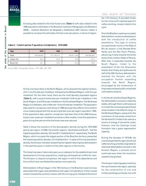
Table 2 - T otal B razilian P opulation (Inhabitants) 1970-2000<br />
Year 1970 1980 1991 2000<br />
Total 94,508,583 121,150,573 146,917,459 169,590,693<br />
Urban (%) 55.9 67.6 75.6 81.2<br />
Rural (%) 44.1 32.4 24.4 18.8<br />
Source: IBGE - Demographic Census - 1970, 1980, 1991, 2000<br />
On the one hand, there is the North Region, which presents the highest relation,<br />
of 317 ha of forests per inhabitant, followed by the Midwest Region, with 9 ha per<br />
inhabitant On the other hand, there are the most densely populated regions<br />
(Table 2), with a scarce forest area per inhabitant: 035 ha per inhabitant in the<br />
South Region, and 030 ha per inhabitant in the Southeast Region The Northeast<br />
Region is in between, with a little over 16 ha of forest per inhabitant The population<br />
data used for comparison were those of 1996 because they reflect a time relation<br />
more closely aligned with the remaining forest cover per region reported in 1995<br />
If the population data used for comparison had been that of the 2000 Census,<br />
forest cover areas per inhabitant would be a little smaller, since the population<br />
grew during that period while the forest area was reduced<br />
Table 2 shows the evolution of the demographic density during the 1970-2000<br />
period, per region In 2000, the smaller regions - Southeast and South - had the<br />
highest population density: 782 and 307 inhabitants/km 2 , respectively The North<br />
Region, which occupies the largest portion of the Brazilian territory, presented<br />
the lowest population density: 33 inhabitant/km 2 In spite of this low population<br />
density, the Amazon has been presenting the highest rates of gross deforestation<br />
in the past few years in relation to the other regions in the country<br />
The forest has been historically seen as an obstacle for the establishment and<br />
development of human populations, creating a philosophical conflict for man<br />
The Amazon is, beyond comparison, the region in which this dependence and<br />
this conflict have manifested themselves more explicitly<br />
Deforestation in Brazil began in the 16th Century in the Brazilian coast and was<br />
associated with sugar cane plantations and sugar-mill operations It then moved<br />
inward, towards the country’s inland, with the mining cycle initiated at the end of<br />
the state of forests<br />
the 17th Century It provided timber<br />
for the mines and it opened space for<br />
cattle-ranching, closely linked to this<br />
cycle<br />
Once the Brazilian coast was occupied,<br />
deforestation moved southeastward,<br />
with the introduction of coffee<br />
plantations This type of culture<br />
occupied lands mainly in the State of<br />
Rio de Janeiro, in the Paraíba River<br />
Valley and the São Paulo Plateau,<br />
advancing, finally, towards the fertile<br />
lands of the northern State of Paraná<br />
After that, it expanded towards the<br />
South Region, linked to the<br />
exploitation of the rich Araucarian<br />
forests And, finally, during the second<br />
half of the 20th Century, deforestation<br />
reached the Amazon with the<br />
occupation frontier expanding<br />
towards the North Region,<br />
encouraged by the construction of<br />
long roads and great public and private<br />
colonisation projects<br />
In the South and Southeast Regions,<br />
the deforestation process is relatively<br />
stable, although there is still pressure<br />
to convert the remaining tropical forest<br />
areas located in the Atlantic slope In<br />
the Northeast Region, pressure for the<br />
conversion of new areas comes from<br />
the demand for timber to be used as a<br />
source of energy It should be noted,<br />
however, that the Caatinga forest<br />
formation has a great regeneration<br />
capacity<br />
During the decades of 1970-80, tax<br />
incentives granted for agricultural and<br />
cattle-ranching activities originated an<br />
extensive deforestation process in the<br />
Amazon Region, a process which<br />
continued even when the incentives<br />
ceased to be granted<br />
The Amazon historiography mentions<br />
the use of wood in the region, specially<br />
for the construction of civil and<br />
military buildings and boats, but until<br />
100


