

GEO Brasil - UNEP
GEO Brasil - UNEP
GEO Brasil - UNEP

Create successful ePaper yourself
Turn your PDF publications into a flip-book with our unique Google optimized e-Paper software.
on the Map of Soils in Brazil (Embrapa,<br />
1981) and on the current Brazilian Soil<br />
Classification System (Embrapa,<br />
1999), 13 main types of soil<br />
classification may be distinguished to<br />
represent Brazilian landscapes Their<br />
extension is presented in Table 1<br />
11 Soil vulnerability to<br />
erosion<br />
Natural vulnerability to erosion is a<br />
function resulting from the interaction<br />
among climate conditions, land<br />
topography and type of soil Through<br />
the analysis of the interaction among<br />
these factors and experimental<br />
estimates of soil losses, it was<br />
possible to establish five degrees of<br />
vulnerability to land erosion in the<br />
country Thus, lowland soils,<br />
hydromorphic or not, plain, very<br />
porous, deep and well-drained such<br />
as those found in plateaus have a very<br />
low or low vulnerability degree, in plain<br />
relief More susceptible to erosion are<br />
commonly sandy soils or those with<br />
remarkable change of texture in depth,<br />
as well as shallow ones Shallow soils<br />
are generally found in dissected<br />
reliefs, with medium, high or very high<br />
degrees of erosion vulnerability to<br />
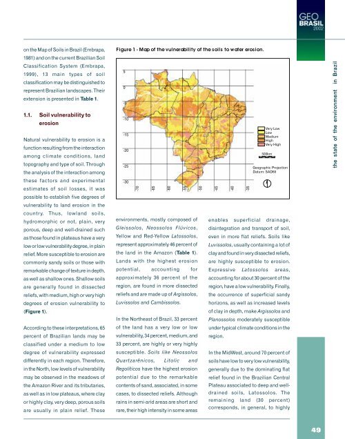
(Figure 1)<br />
According to these interpretations, 65<br />
percent of Brazilian lands may be<br />
classified under a medium to low<br />
degree of vulnerability expressed<br />
differently in each region Therefore,<br />
in the North, low levels of vulnerability<br />
may be observed in the meadows of<br />
the Amazon River and its tributaries,<br />
as well as in low plateaus, where clay<br />
or highly clay, very deep, porous soils<br />
are usually in plain relief These<br />
Figure 1- Map of the vulnerability of the soils to water erosion.<br />
5<br />
0<br />
-5<br />
-10<br />
-15<br />
-20<br />
-25<br />
-30<br />
-70<br />
-65<br />
-60<br />
-55<br />
environments, mostly composed of<br />
Gleissolos, Neossolos Flúvicos,<br />
Yellow and Red-Yellow Latossolos,<br />
represent approximately 46 percent of<br />
the land in the Amazon (Table 1)<br />
Lands with the highest erosion<br />
potential, accounting for<br />
approximately 36 percent of the<br />
region, are found in more dissected<br />
reliefs and are made up of Argissolos,<br />
Luvissolos and Cambissolos<br />
In the Northeast of Brazil, 33 percent<br />
of the land has a very low or low<br />
vulnerability, 34 percent, medium, and<br />
33 percent, are highly or very highly<br />
susceptible Soils like Neossolos<br />
Quartzarênicos, Litolic and<br />
Regolíticos have the highest erosion<br />
potential due to the remarkable<br />
contents of sand, associated, in some<br />
cases, to dissected reliefs Although<br />
rains in semi-arid areas are short and<br />
rare, their high intensity in some areas<br />
-50<br />
-45<br />
-40<br />
-35<br />
Very Low<br />
Low<br />
Medium<br />
High<br />
Very High<br />
500km<br />
Geographic Projection<br />
Datum: SAD69<br />
enables superficial drainage,<br />
disintegration and transport of soil,<br />
even in more flat reliefs Soils like<br />
Luvissolos, usually containing a lot of<br />
clay and found in very dissected reliefs,<br />
are highly susceptible to erosion<br />
Expressive Latossolos areas,<br />
accounting for about 30 percent of the<br />
region, have a low vulnerability Finally,<br />
the occurrence of superficial sandy<br />
horizons, as well as increased levels<br />
of clay in depth, make Argissolos and<br />
Planossolos moderately susceptible<br />
under typical climate conditions in the<br />
region<br />
In the MidWest, around 70 percent of<br />
soils have low to very low vulnerability,<br />
generally due to the dominating flat<br />
relief found in the Brazilian Central<br />
Plateau associated to deep and welldrained<br />
soils, Latossolos The<br />
remaining land (30 percent)<br />
corresponds, in general, to highly<br />
the state of the environment in Brazil<br />
49


