

TRD 05: Data Presentation techniques (Mapping) Quantum GIS ...
TRD 05: Data Presentation techniques (Mapping) Quantum GIS ...
TRD 05: Data Presentation techniques (Mapping) Quantum GIS ...

You also want an ePaper? Increase the reach of your titles
YUMPU automatically turns print PDFs into web optimized ePapers that Google loves.
3.6 Measuring<br />
features are read from the datastore, choose Preferences from the Settings menu and click on the<br />
Rendering tab. Set the feature count to an appropriate value to update the display during rendering.<br />
Setting a value of 0 disables update during drawing (this is the default). Setting a value too low<br />
will result in poor performance as the map canvas is continually updated during the reading of the<br />
features. A suggested value to start with is 500.<br />
NOTE: This feature is currently disabled because it does not works as expected under Qt 4.2.<br />
3.6. Measuring<br />
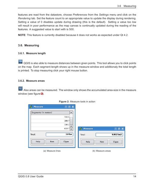
3.6.1. Measure length<br />
Q<strong>GIS</strong> is also able to measure distances between given points. This tool allows you to click points<br />
on the map. Each segment-length shows up in the measure-window and additionaly the total length<br />
is printed. To stop measuring click your right mouse button.<br />
3.6.2. Measure areas<br />
Also areas can be measured. The window only shows the accumulated area-size in the measure<br />
window (see figure 2).<br />
Figure 2: Measure tools in action<br />
(a) Measure lines<br />
(b) Measure areas<br />
Q<strong>GIS</strong> 0.8 User Guide 14


