

TRD 05: Data Presentation techniques (Mapping) Quantum GIS ...
TRD 05: Data Presentation techniques (Mapping) Quantum GIS ...
TRD 05: Data Presentation techniques (Mapping) Quantum GIS ...

Create successful ePaper yourself
Turn your PDF publications into a flip-book with our unique Google optimized e-Paper software.
10.2 Using the GPS Plugin<br />
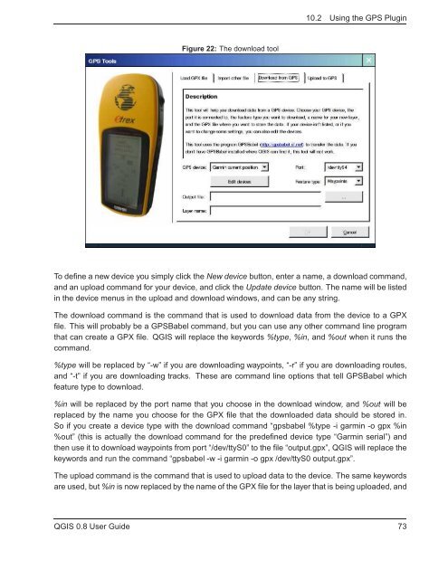
Figure 22: The download tool<br />
To define a new device you simply click the New device button, enter a name, a download command,<br />
and an upload command for your device, and click the Update device button. The name will be listed<br />
in the device menus in the upload and download windows, and can be any string.<br />
The download command is the command that is used to download data from the device to a GPX<br />
file. This will probably be a GPSBabel command, but you can use any other command line program<br />
that can create a GPX file. Q<strong>GIS</strong> will replace the keywords %type, %in, and %out when it runs the<br />
command.<br />
%type will be replaced by “-w” if you are downloading waypoints, “-r” if you are downloading routes,<br />
and “-t” if you are downloading tracks. These are command line options that tell GPSBabel which<br />
feature type to download.<br />
%in will be replaced by the port name that you choose in the download window, and %out will be<br />
replaced by the name you choose for the GPX file that the downloaded data should be stored in.<br />
So if you create a device type with the download command “gpsbabel %type -i garmin -o gpx %in<br />
%out” (this is actually the download command for the predefined device type “Garmin serial”) and<br />
then use it to download waypoints from port “/dev/ttyS0” to the file “output.gpx”, Q<strong>GIS</strong> will replace the<br />
keywords and run the command “gpsbabel -w -i garmin -o gpx /dev/ttyS0 output.gpx”.<br />
The upload command is the command that is used to upload data to the device. The same keywords<br />
are used, but %in is now replaced by the name of the GPX file for the layer that is being uploaded, and<br />
Q<strong>GIS</strong> 0.8 User Guide 73


