

TRD 05: Data Presentation techniques (Mapping) Quantum GIS ...
TRD 05: Data Presentation techniques (Mapping) Quantum GIS ...
TRD 05: Data Presentation techniques (Mapping) Quantum GIS ...

You also want an ePaper? Increase the reach of your titles
YUMPU automatically turns print PDFs into web optimized ePapers that Google loves.
10.2 Using the GPS Plugin<br />
10.2. Using the GPS Plugin<br />
10.2.1. What is GPS?<br />
GPS, the Global Positioning System, is a satellite-based system that allows anyone with a GPS<br />
receiver to find their exact position anywhere in the world. It is used as an aid in navigation, for<br />
example in airplanes, in boats, and by hikers. The GPS receiver uses the signals from the satellites<br />
to calculate its latitude, longitude and (sometimes) elevation. Most receivers also have the capability<br />
to store locations (known as waypoints), sequences of locations that make up a planned route, and<br />
a tracklog or track of the receivers movement over time. Waypoints, routes, and tracks are the three<br />
basic feature types in GPS data. Q<strong>GIS</strong> displays waypoints in point layers while routes and tracks are<br />
displayed in linestring layers.<br />
10.2.2. Loading GPS data from a file<br />
There are dozens of different file formats for storing GPS data. The format that Q<strong>GIS</strong> uses is called<br />
GPX (GPS eXchange format), which is a standard interchange format that can contain any number<br />
of waypoints, routes, and tracks in the same file.<br />
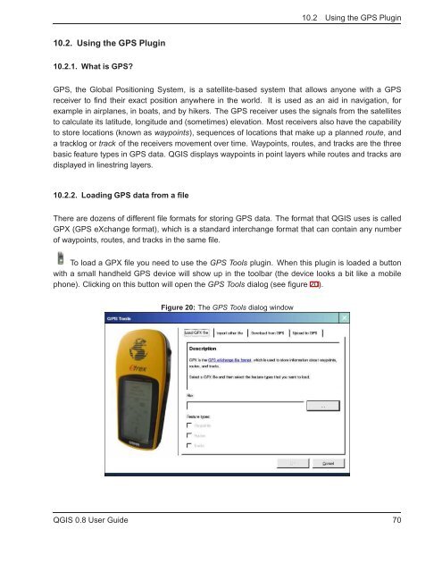
To load a GPX file you need to use the GPS Tools plugin. When this plugin is loaded a button<br />
with a small handheld GPS device will show up in the toolbar (the device looks a bit like a mobile<br />
phone). Clicking on this button will open the GPS Tools dialog (see figure 20).<br />
Figure 20: The GPS Tools dialog window<br />
Q<strong>GIS</strong> 0.8 User Guide 70


