TRD 05: Data Presentation techniques (Mapping) Quantum GIS ...
TRD 05: Data Presentation techniques (Mapping) Quantum GIS ...
TRD 05: Data Presentation techniques (Mapping) Quantum GIS ...
Create successful ePaper yourself
Turn your PDF publications into a flip-book with our unique Google optimized e-Paper software.
List of Figures<br />
List of Figures<br />
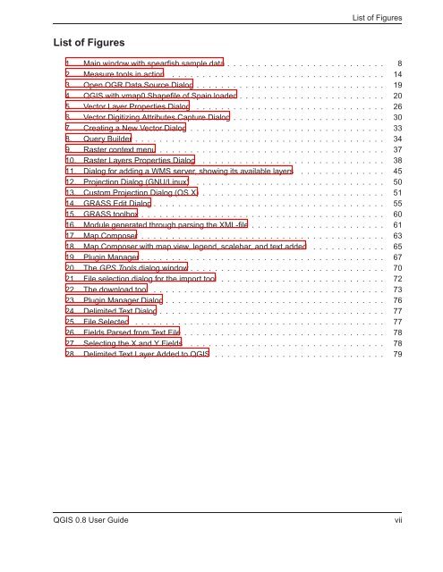
1. Main window with spearfish sample data . . . . . . . . . . . . . . . . . . . . . . . . . . 8<br />
2. Measure tools in action . . . . . . . . . . . . . . . . . . . . . . . . . . . . . . . . . . . 14<br />
3. Open OGR <strong>Data</strong> Source Dialog . . . . . . . . . . . . . . . . . . . . . . . . . . . . . . . 19<br />
4. Q<strong>GIS</strong> with vmap0 Shapefile of Spain loaded . . . . . . . . . . . . . . . . . . . . . . . . 20<br />
5. Vector Layer Properties Dialog . . . . . . . . . . . . . . . . . . . . . . . . . . . . . . . 26<br />
6. Vector Digitizing Attributes Capture Dialog . . . . . . . . . . . . . . . . . . . . . . . . . 30<br />
7. Creating a New Vector Dialog . . . . . . . . . . . . . . . . . . . . . . . . . . . . . . . . 33<br />
8. Query Builder . . . . . . . . . . . . . . . . . . . . . . . . . . . . . . . . . . . . . . . . . 34<br />
9. Raster context menu . . . . . . . . . . . . . . . . . . . . . . . . . . . . . . . . . . . . . 37<br />
10. Raster Layers Properties Dialog . . . . . . . . . . . . . . . . . . . . . . . . . . . . . . 38<br />
11. Dialog for adding a WMS server, showing its available layers . . . . . . . . . . . . . . 45<br />
12. Projection Dialog (GNU/Linux) . . . . . . . . . . . . . . . . . . . . . . . . . . . . . . . 50<br />
13. Custom Projection Dialog (OS X) . . . . . . . . . . . . . . . . . . . . . . . . . . . . . . 51<br />
14. GRASS Edit Dialog . . . . . . . . . . . . . . . . . . . . . . . . . . . . . . . . . . . . . . 55<br />
15. GRASS toolbox . . . . . . . . . . . . . . . . . . . . . . . . . . . . . . . . . . . . . . . . 60<br />
16. Module generated through parsing the XML-file . . . . . . . . . . . . . . . . . . . . . . 61<br />
17. Map Composer . . . . . . . . . . . . . . . . . . . . . . . . . . . . . . . . . . . . . . . . 63<br />
18. Map Composer with map view, legend, scalebar, and text added . . . . . . . . . . . . 65<br />
19. Plugin Manager . . . . . . . . . . . . . . . . . . . . . . . . . . . . . . . . . . . . . . . . 67<br />
20. The GPS Tools dialog window . . . . . . . . . . . . . . . . . . . . . . . . . . . . . . . . 70<br />
21. File selection dialog for the import tool . . . . . . . . . . . . . . . . . . . . . . . . . . . 72<br />
22. The download tool . . . . . . . . . . . . . . . . . . . . . . . . . . . . . . . . . . . . . . 73<br />
23. Plugin Manager Dialog . . . . . . . . . . . . . . . . . . . . . . . . . . . . . . . . . . . . 76<br />
24. Delimited Text Dialog . . . . . . . . . . . . . . . . . . . . . . . . . . . . . . . . . . . . . 77<br />
25. File Selected . . . . . . . . . . . . . . . . . . . . . . . . . . . . . . . . . . . . . . . . . 77<br />
26. Fields Parsed from Text File . . . . . . . . . . . . . . . . . . . . . . . . . . . . . . . . . 78<br />
27. Selecting the X and Y Fields . . . . . . . . . . . . . . . . . . . . . . . . . . . . . . . . 78<br />
28. Delimited Text Layer Added to Q<strong>GIS</strong> . . . . . . . . . . . . . . . . . . . . . . . . . . . . 79<br />
Q<strong>GIS</strong> 0.8 User Guide<br />
vii


