

TRD 05: Data Presentation techniques (Mapping) Quantum GIS ...
TRD 05: Data Presentation techniques (Mapping) Quantum GIS ...
TRD 05: Data Presentation techniques (Mapping) Quantum GIS ...

You also want an ePaper? Increase the reach of your titles
YUMPU automatically turns print PDFs into web optimized ePapers that Google loves.
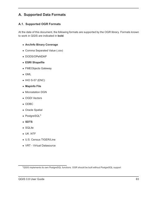
A. Supported <strong>Data</strong> Formats<br />
A.1. Supported OGR Formats<br />
At the date of this document, the following formats are supported by the OGR library. Formats known<br />
to work in Q<strong>GIS</strong> are indicated in bold.<br />
• Arc/Info Binary Coverage<br />
• Comma Separated Value (.csv)<br />
• DODS/OPeNDAP<br />
• ESRI Shapefile<br />
• FMEObjects Gateway<br />
• GML<br />
• IHO S-57 (ENC)<br />
• Mapinfo File<br />
• Microstation DGN<br />
• OGDI Vectors<br />
• ODBC<br />
• Oracle Spatial<br />
• PostgreSQL 3<br />
• SDTS<br />
• SQLite<br />
• UK .NTF<br />
• U.S. Census TIGER/Line<br />
• VRT - Virtual <strong>Data</strong>source<br />
3 Q<strong>GIS</strong> implements its own PostgreSQL functions. OGR should be built without PostgreSQL support<br />
Q<strong>GIS</strong> 0.8 User Guide 83


