

TRD 05: Data Presentation techniques (Mapping) Quantum GIS ...
TRD 05: Data Presentation techniques (Mapping) Quantum GIS ...
TRD 05: Data Presentation techniques (Mapping) Quantum GIS ...

You also want an ePaper? Increase the reach of your titles
YUMPU automatically turns print PDFs into web optimized ePapers that Google loves.
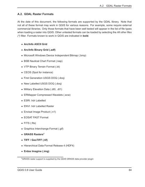
A.2 GDAL Raster Formats<br />
A.2. GDAL Raster Formats<br />
At the date of this document, the following formats are supported by the GDAL library. Note that<br />
not all of these format may work in Q<strong>GIS</strong> for various reasons. For example, some require external<br />
commercial libraries. Only those formats that have been well tested will appear in the list of file types<br />
when loading a raster into Q<strong>GIS</strong>. Other untested formats can be loaded by selecting the All other files<br />
(*) filter. Formats known to work in Q<strong>GIS</strong> are indicated in bold.<br />
• Arc/Info ASCII Grid<br />
• Arc/Info Binary Grid (.adf)<br />
• Microsoft Windows Device Independent Bitmap (.bmp)<br />
• BSB Nautical Chart Format (.kap)<br />
• VTP Binary Terrain Format (.bt)<br />
• CEOS (Spot for instance)<br />
• First Generation USGS DOQ (.doq)<br />
• New Labelled USGS DOQ (.doq)<br />
• Military Elevation <strong>Data</strong> (.dt0, .dt1)<br />
• ERMapper Compressed Wavelets (.ecw)<br />
• ESRI .hdr Labelled<br />
• ENVI .hdr Labelled Raster<br />
• Envisat Image Product (.n1)<br />
• EOSAT FAST Format<br />
• FITS (.fits)<br />
• Graphics Interchange Format (.gif)<br />
• GRASS Rasters 4<br />
• TIFF / GeoTIFF (.tif)<br />
• Hierarchical <strong>Data</strong> Format Release 4 (HDF4)<br />
• Erdas Imagine (.img)<br />
4 GRASS raster support is supplied by the Q<strong>GIS</strong> GRASS data provider plugin<br />
Q<strong>GIS</strong> 0.8 User Guide 84


