

TRD 05: Data Presentation techniques (Mapping) Quantum GIS ...
TRD 05: Data Presentation techniques (Mapping) Quantum GIS ...
TRD 05: Data Presentation techniques (Mapping) Quantum GIS ...

You also want an ePaper? Increase the reach of your titles
YUMPU automatically turns print PDFs into web optimized ePapers that Google loves.
6.2 WMS Client<br />
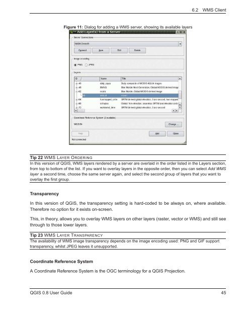
Figure 11: Dialog for adding a WMS server, showing its available layers<br />
Tip 22 WMS LAYER ORDERING<br />
In this version of Q<strong>GIS</strong>, WMS layers rendered by a server are overlaid in the order listed in the Layers section,<br />
from top to bottom of the list. If you want to overlay layers in the opposite order, then you can select Add WMS<br />
layer a second time, choose the same server again, and select the second group of layers that you want to<br />
overlay the first group.<br />
Transparency<br />
In this version of Q<strong>GIS</strong>, the transparency setting is hard-coded to be always on, where available.<br />
Therefore no option for it exists on-screen.<br />
This, in theory, allows you to overlay WMS layers on other layers (raster, vector or WMS) and still see<br />
through to those lower layers.<br />
Tip 23 WMS LAYER TRANSPARENCY<br />
The availability of WMS image transparency depends on the image encoding used: PNG and GIF support<br />
transparency, whilst JPEG leaves it unsupported.<br />
Coordinate Reference System<br />
A Coordinate Reference System is the OGC terminology for a Q<strong>GIS</strong> Projection.<br />
Q<strong>GIS</strong> 0.8 User Guide 45


