Network Statement 2014 - ProRail
Network Statement 2014 - ProRail
Network Statement 2014 - ProRail
- No tags were found...
You also want an ePaper? Increase the reach of your titles
YUMPU automatically turns print PDFs into web optimized ePapers that Google loves.
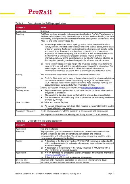
Table 3.1CategoryApplicationFunctionDescription of the RailMaps applicationNotesRailMapsRailMaps provides access to various geographical data of <strong>ProRail</strong>. Visual access tothe information is possible by means of maps at various levels of detailing (macro ormicro level). Examples include trackside structures, aerial photos of the tracks, InfraAtlas (a) and route section videos (b).a) Infra Atlas provides data on the topology and technical functionalities of therailway network. Included under topology are items such as points, buffer stopsor branch sections. Technical functionalities include signals, rail signals, weldsand speed signs. In order to enable railway undertakings to prepare theirapplication for timetable capacity, the application is also made available withinthe framework of the capacity allocation process. <strong>ProRail</strong> provides thisinformation not only for the current situation, but also for the future situation sothat long-term planning can take changes in the infrastructure into account.b) Route section videos provides insight into structures located on and along theroute section, as well as in the immediate surroundings of the railway line. Thevideo images can serve as an aid in driver training or for the remotereconnaissance of local situations. 90% of the images are updated 2x a year.FacilityThe information is acquired on the basis of an Internet authorisation.a) For Infra Atlas, data on the basis of the requirements of the railway undertakingcan be acquired within the standard delivery package (as described in IRSIAUF (Interface Requirement Specification Infra Atlas Exchange Format); theaccount manager can provide further information on this).ApplicationVia the Servicedesk Infrastructure information (infrainformatie@prorail.nl)Delivery terms • Reproduction and/or publication, or use by or for third parties or other servicesor systems is prohibited·• Changes to the data that cause conflict with the original data are prohibited.• The data may not be used for any other purpose than for which they have beenprovided by <strong>ProRail</strong>.User conditionsMs Office and Internet Explorer.Availability / Reliabilitya) As regards data delivery from Infra Atlas, recipient is responsible for the read-inof the datafile in its own system.7 x 24 hours availability, with the exception of emergencies and maintenance.The helpdesk is available from Monday until Friday from 08:00 to 17:00 hours.Table 3.2CategoryDescription of the Signs applicationNotesApplicationFunctionFacilityApplicationDelivery timeUser conditionsRail and road signsSigns provide a graphic overview of infrastructure, tailored to the needs of traindrivers, to facilitate safe and efficient traffic participation and effectivecommunication with traffic control. The infrastructure concerns at least the entirenetwork centrally operated by <strong>ProRail</strong>.a) A download of the Signs for Traction (WVK) in PDF format via a webportal. Bytaking a subscription to the webportal, changes are communicated by means ofan e-mail message.b) A description of the positions of the railway structures in XML format with aWVK notification of relevant changesa) A WVK download via a webportal: at the Servicedesk Infrastructure information(infrainformatie@prorail.nl)b) A description in XML format: via Account ManagementMaximum of 24 hours after application for an account (during working days).Ms Office, Internet Explorer and Adobe Acrobat Reader<strong>Network</strong> <strong>Statement</strong> <strong>2014</strong> Combined <strong>Network</strong> - version 1.0 dated 9 January 2013 page 22


