Program Delivery Plan
Program Delivery Plan - Baton Rouge Department of Public Works ...
Program Delivery Plan - Baton Rouge Department of Public Works ...
- No tags were found...

Create successful ePaper yourself
Turn your PDF publications into a flip-book with our unique Google optimized e-Paper software.
SECTION 4. CENTRAL BASIN PROJECTS<br />
4.2.14 CC-EAST-PS (Central Consolidated PSs)<br />
Project Description<br />
Purpose of the Project/Project Background<br />
The CC-EAST-PS (Central Consolidated Pump Stations) Project involves the design and<br />
construction of nine pump stations (PS 2, PS 3, PS 4, PS 5, PS 6, PS 7, PS 10, PS 91, and the<br />
Glasgow Pump Station). Three pump stations (PS 2, PS 7, and PS 10) are to be interconnected<br />
in a network that will discharge into PS 5. PS 5 will pump directly to the South WWTP via a<br />
new large forcemain following completion of construction of the South WWTP – Phase I<br />
project, which is currently in the design phase. PS 3, PS 91, and the Glasgow Pump Station<br />
will each pump independently to PS 5 through two separate new forcemains. PS 4 pumps to<br />
PS 3 through an existing forcemain. PS 6 will pump through a new 12–inch forcemain that<br />
will replace the existing forcemain from PS 6 along Stanford Avenue northeast to node PS 6DS<br />
(MH 002-01393), located near the intersection of South Lakeshore Drive and Stanford Avenue.<br />
The forcemains from PS 2, PS 3, PS 5, PS 7, and PS 10 will be constructed as part of the<br />
CC-EAST-FM (Central Consolidated Forcemains) project. The forcemains from PS 6, PS 91,<br />
and the Glasgow Pump Station will be constructed as part of the CGS-C-0004 (Highland<br />
Road – Buchanan Street Sewer Area Upgrades) project.<br />
Location<br />
The CC-EAST-PS (Consolidated Pump Stations) project is primarily located in the Central<br />
Baton Rouge area. Detailed location descriptions of the required capacity improvements are<br />
presented in Table 4-10and are shown in Figure 4-16.<br />
Scope<br />
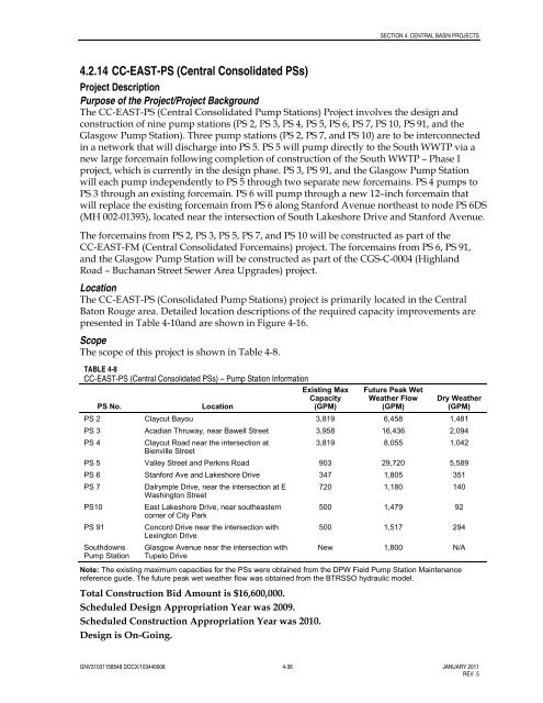
The scope of this project is shown in Table 4-8.<br />
TABLE 4-8<br />
CC-EAST-PS (Central Consolidated PSs) – Pump Station Information<br />
PS No.<br />
Location<br />
Existing Max<br />
Capacity<br />
(GPM)<br />
Future Peak Wet<br />
Weather Flow<br />
(GPM)<br />
Dry Weather<br />
(GPM)<br />
PS 2 Claycut Bayou 3,819 6,458 1,481<br />
PS 3 Acadian Thruway, near Bawell Street 3,958 16,436 2,094<br />
PS 4<br />
Claycut Road near the intersection at<br />
3,819 8,055 1,042<br />
Bienville Street<br />
PS 5 Valley Street and Perkins Road 903 29,720 5,589<br />
PS 6 Stanford Ave and Lakeshore Drive 347 1,805 351<br />
PS 7<br />
Dalrymple Drive, near the intersection at E 720 1,180 140<br />
Washington Street<br />
PS10<br />
East Lakeshore Drive, near southeastern 500 1,479 92<br />
corner of City Park<br />
PS 91<br />
Concord Drive near the intersection with<br />
500 1,517 294<br />
Lexington Drive<br />
Southdowns<br />
Pump Station<br />
Glasgow Avenue near the intersection with<br />
Tupelo Drive<br />
New 1,800 N/A<br />
Note: The existing maximum capacities for the PSs were obtained from the DPW Field Pump Station Maintenance<br />
reference guide. The future peak wet weather flow was obtained from the BTRSSO hydraulic model.<br />
Total Construction Bid Amount is $16,600,000.<br />
Scheduled Design Appropriation Year was 2009.<br />
Scheduled Construction Appropriation Year was 2010.<br />
Design is On-Going.<br />
GNV31031158548.DOCX/103440008 4-36 JANUARY 2011<br />
REV. 5