

PDF 20.134kB - TOBIAS-lib - Universität Tübingen
PDF 20.134kB - TOBIAS-lib - Universität Tübingen
PDF 20.134kB - TOBIAS-lib - Universität Tübingen

Erfolgreiche ePaper selbst erstellen
Machen Sie aus Ihren PDF Publikationen ein blätterbares Flipbook mit unserer einzigartigen Google optimierten e-Paper Software.
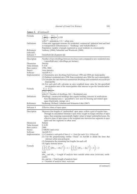
Annex 1. (Continued)<br />
Formula<br />
P<br />
Pt<br />
P<br />
UAt<br />
P<br />
Pt 1<br />
P<br />
UAt 1<br />
·100<br />
Definitions<br />
with P = population, UA = urban area<br />
Urban area: aggregate measure for residential, commercial, industrial land and land<br />
in transportation infrastructure (= ‘Siedlungs- und Verkehrsfläche’)<br />
Population: number of people registered as usual residents in a municipality<br />
References<br />
(selected)<br />
Anthony (2004), Schneider and Woodcock (2008)<br />
Indicator 3 Greenfield development rate<br />
Description Number of new dwellings between two base years compared to new residential area<br />
(‘greenfield area’) (dwellings per hectare)<br />
Dimension Density<br />
Value domain 0–610<br />
Base year(s) 1996, 2004<br />
Source Area statistics<br />
Software ArcGIS 9.2<br />
Implementation (1) Summarise new dwellings built between 1996 and 2004 per municipality<br />
(2) Subtract residential area 1996 from residential area 2004 for each municipality<br />
(3) Calculate the ratio between summarised dwellings and residential area result per<br />
municipality<br />
(4) For each grid cell, calculate an area weighted mean value for the greenfield<br />
Formula<br />
P<br />
development<br />
P<br />
rates of the municipalities that intersect as per the formula below<br />
Dt Dt 1<br />
P RAt<br />
P RAt 1<br />
with D = Number of dwellings, RA = Residential area<br />
Definitions Dwellings: constructed buildings that require building consents or notifications<br />
New Residential area (= ‘greenfield’): new area for housing and related open<br />
space (backyards, storage, etc.)<br />
References Siedentop, Heiland, Lehmann and Schauerte-Lüke (2007)<br />
Indicator 4 Effective share of open space<br />
Description Measures line lengths of ‘undisturbed’ open space within a grid of regular lines.<br />
Through its calculation formulae it puts more weight on longer stretches of open<br />
space, thus assigning exponentially higher values to larger undisturbed areas; the<br />
effective share of open space is the weighted ratio between line segments in open<br />
space and line segments in urban areas<br />
Dimension Pattern<br />
Value domain 0–0.89<br />
Base year(s) 2000<br />
Source CORINE land cover<br />
Software ArcGIS 9.2<br />
Implementation (1) Construct a sub-grid of lines (1 · 1 km) for each 10 · 10 km cell<br />
(2) Use the geoprocessing routine ‘‘Erase’’ in ArcGIS to delete the lines that<br />
intersect urban area polygons<br />
(3) Summarise the remaining line lengths for each cell<br />
Formula<br />
(4) Apply formula below<br />
Pn Pmi !<br />
2<br />
n þ Pk Pli !<br />
2<br />
!<br />
k 2<br />
dfwi;j dwi<br />
i¼1 j¼1<br />
Journal of Land Use Science 101<br />
dfsi;j dsi<br />
i¼1 j¼1<br />
with<br />
dfw i,j and dfs i,j = Length of analysis lines outside urban areas (west-east; northsouth)<br />
dwi and dsi = Total length of analysis lines<br />
n = Number of analysis lines, west-east<br />
(Continued )


