

PDF 20.134kB - TOBIAS-lib - Universität Tübingen
PDF 20.134kB - TOBIAS-lib - Universität Tübingen
PDF 20.134kB - TOBIAS-lib - Universität Tübingen

Sie wollen auch ein ePaper? Erhöhen Sie die Reichweite Ihrer Titel.
YUMPU macht aus Druck-PDFs automatisch weboptimierte ePaper, die Google liebt.
Stefan Fina Patterns of Urban Sprawl Geographical Analysis<br />
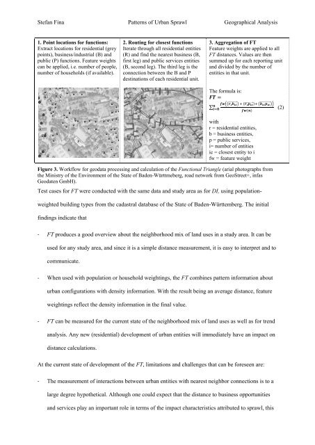
1. Point locations for functions:<br />
Extract locations for residential (grey<br />
points), business/industrial (B) and<br />
public (P) functions. Feature weights<br />
can be applied, i.e. number of people,<br />
number of households (if available).<br />
2. Routing for closest functions<br />
Iterate through all residential entities<br />
(R) and find the nearest business (B,<br />
first leg) and public services entities<br />
(B, second leg). The third leg is the<br />
connection between the B and P<br />
destinations of each residential unit.<br />
3. Aggregation of FT<br />
Feature weights are applied to all<br />
FT distances. Values are then<br />
summed up for each reporting unit<br />
and divided by the number of<br />
entities in that unit.<br />
The formula is:<br />
=<br />
∑<br />
<br />
⃗ ( ⃗) <br />
⃗<br />
<br />
<br />
()<br />
with<br />
r = residential entities,<br />
b = business entities,<br />
p = public services,<br />
i= number of entities<br />
ic = closest entity to i<br />
fw = feature weight<br />
Figure 3. Workflow for geodata processing and calculation of the Functional Triangle (arial photographs from<br />
the Ministry of the Environment of the State of Baden-Württmeberg, road network from GeoStreet+, infas<br />
Geodaten GmbH).<br />
Test cases for FT were conducted with the same data and study area as for DI, using population-<br />
weighted building types from the cadastral database of the State of Baden-Württemberg. The initial<br />
findings indicate that<br />
- FT produces a good overview about the neighborhood mix of land uses in a study area. It can be<br />
used for any study area, and since it is a simple distance measurement, it is easy to interpret and to<br />
communicate.<br />
- When used with population or household weightings, the FT combines pattern information about<br />
urban configurations with density information. With the result being an average distance, feature<br />
weightings reflect the density information in the final value.<br />
- FT can be measured for the current state of the neighborhood mix of land uses as well as for trend<br />
analysis. Any new (residential) development of urban entities will immediately have an impact on<br />
distance calculations.<br />
At the current state of development of the FT, limitations and challenges that can be foreseen are:<br />
- The measurement of interactions between urban entities with nearest neighbor connections is to a<br />
large degree hypothetical. Although one could expect that the distance to business opportunities<br />
and services play an important role in terms of the impact characteristics attributed to sprawl, this<br />
(2)


