

PDF 20.134kB - TOBIAS-lib - Universität Tübingen
PDF 20.134kB - TOBIAS-lib - Universität Tübingen
PDF 20.134kB - TOBIAS-lib - Universität Tübingen

Sie wollen auch ein ePaper? Erhöhen Sie die Reichweite Ihrer Titel.
YUMPU macht aus Druck-PDFs automatisch weboptimierte ePaper, die Google liebt.
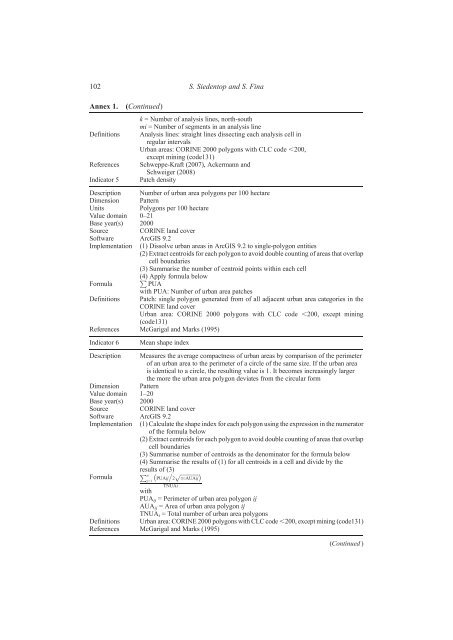
102 S. Siedentop and S. Fina<br />
Annex 1. (Continued)<br />
k = Number of analysis lines, north-south<br />
mi = Number of segments in an analysis line<br />
Definitions Analysis lines: straight lines dissecting each analysis cell in<br />
regular intervals<br />
Urban areas: CORINE 2000 polygons with CLC code ,200,<br />
except mining (code131)<br />
References Schweppe-Kraft (2007), Ackermann and<br />
Schweiger (2008)<br />
Indicator 5 Patch density<br />
Description Number of urban area polygons per 100 hectare<br />
Dimension Pattern<br />
Units Polygons per 100 hectare<br />
Value domain 0–21<br />
Base year(s) 2000<br />
Source CORINE land cover<br />
Software ArcGIS 9.2<br />
Implementation (1) Dissolve urban areas in ArcGIS 9.2 to single-polygon entities<br />
(2) Extract centroids for each polygon to avoid double counting of areas that overlap<br />
cell boundaries<br />
(3) Summarise the number of centroid points within each cell<br />
Formula<br />
(4) P Apply formula below<br />
PUA<br />
with PUA: Number of urban area patches<br />
Definitions Patch: single polygon generated from of all adjacent urban area categories in the<br />
CORINE land cover<br />
Urban area: CORINE 2000 polygons with CLC code ,200, except mining<br />
(code131)<br />
References McGarigal and Marks (1995)<br />
Indicator 6 Mean shape index<br />
Description Measures the average compactness of urban areas by comparison of the perimeter<br />
of an urban area to the perimeter of a circle of the same size. If the urban area<br />
is identical to a circle, the resulting value is 1. It becomes increasingly larger<br />
the more the urban area polygon deviates from the circular form<br />
Dimension Pattern<br />
Value domain 1–20<br />
Base year(s) 2000<br />
Source CORINE land cover<br />
Software ArcGIS 9.2<br />
Implementation (1) Calculate the shape index for each polygon using the expression in the numerator<br />
of the formula below<br />
(2) Extract centroids for each polygon to avoid double counting of areas that overlap<br />
cell boundaries<br />
(3) Summarise number of centroids as the denominator for the formula below<br />
(4) Summarise the results of (1) for all centroids in a cell and divide by the<br />
Formula<br />
results of (3)<br />
p<br />
Pn j¼1<br />
PUAij 2<br />
TNUAi<br />
ffiffiffiffiffiffiffiffiffiffiffiffiffi<br />
AUAij<br />
with<br />
PUAij = Perimeter of urban area polygon ij<br />
AUAij = Area of urban area polygon ij<br />
TNUA i = Total number of urban area polygons<br />
Definitions Urban area: CORINE 2000 polygons with CLC code ,200, except mining (code131)<br />
References McGarigal and Marks (1995)<br />
(Continued )


