Attachment 1-7 - City of Ryde
Attachment 1-7 - City of Ryde
Attachment 1-7 - City of Ryde

Create successful ePaper yourself
Turn your PDF publications into a flip-book with our unique Google optimized e-Paper software.
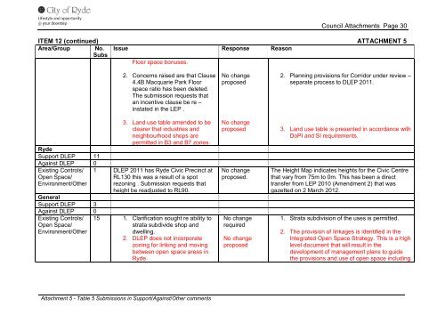
Council <strong>Attachment</strong>s Page 30<br />
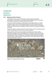
ITEM 12 (continued) ATTACHMENT 5<br />
Area/Group No.<br />
Subs<br />
Issue Response Reason<br />
Floor space bonuses.<br />
<strong>Ryde</strong><br />
Support DLEP 11<br />
Against DLEP 0<br />
Existing Controls/<br />
Open Space/<br />
Environment/Other<br />
General<br />
Support DLEP 3<br />
Against DLEP 0<br />
Existing Controls/<br />
Open Space/<br />
Environment/Other<br />
2. Concerns raised are that Clause<br />
4.4B Macquarie Park Floor<br />
space ratio has been deleted.<br />
The submission requests that<br />
an incentive clause be re –<br />
instated in the LEP .<br />
3. Land use table amended to be<br />
clearer that industries and<br />
neighbourhood shops are<br />
permitted in B3 and B7 zones.<br />
1 DLEP 2011 has <strong>Ryde</strong> Civic Precinct at<br />
RL130 this was a result <strong>of</strong> a spot<br />
rezoning . Submission requests that<br />
height be readjusted to RL90.<br />
15 1. Clarification sought re ability to<br />
strata subdivide shop and<br />
dwelling.<br />
2. DLEP does not incorporate<br />
zoning for linking and moving<br />
between open space areas in<br />
<strong>Ryde</strong>.<br />
<strong>Attachment</strong> 5 - Table 5 Submissions in Support/Against/Other comments<br />
No change<br />
proposed<br />
No change<br />
proposed<br />
No change<br />
proposed.<br />
No change<br />
required<br />
No change<br />
proposed<br />
2. Planning provisions for Corridor under review –<br />
separate process to DLEP 2011.<br />
3. Land use table is presented in accordance with<br />
DoPI and SI requirements.<br />
The Height Map indicates heights for the Civic Centre<br />
that vary from 75m to 0m. This has been a direct<br />
transfer from LEP 2010 (Amendment 2) that was<br />
gazetted on 2 March 2012.<br />
1. Strata subdivision <strong>of</strong> the uses is permitted.<br />
2. The provision <strong>of</strong> linkages is identified in the<br />
Integrated Open Space Strategy. This is a high<br />
level document that will result in the<br />
development <strong>of</strong> management plans to guide<br />
the provisions and use <strong>of</strong> open space including