REFERENCE MANUAL - FTP Directory Listing - Trimble
REFERENCE MANUAL - FTP Directory Listing - Trimble
REFERENCE MANUAL - FTP Directory Listing - Trimble

You also want an ePaper? Increase the reach of your titles
YUMPU automatically turns print PDFs into web optimized ePapers that Google loves.
A<br />
TRIMBLE STANDARD INTERFACE PROTOCOL (TSIP)<br />
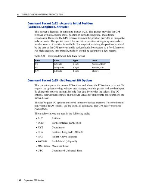
Command Packet 0x32 - Accurate Initial Position,<br />
(Latitude, Longitude, Altitude)<br />
This packet is identical in content to Packet 0x2B. This packet provides the GPS<br />
receiver with an accurate initial position in latitude, longitude, and altitude<br />
coordinates. However, the GPS receiver assumes the position provided in this packet<br />
to be accurate. This packet is used for satellite acquisition aiding in systems where<br />
another source of position is available. For acquisition aiding, the position provided<br />
by the user to the GPS receiver in this packet should be accurate to a few kilometers.<br />
For high-accuracy time transfer, position should be accurate to a few meters.<br />
Table A.20<br />
Command Packet 0x32 Data Format<br />
Byte Item Type Units<br />
0-3 Latitude Single Radians, North<br />
4-7 Longitude Single Radians, East<br />
8-11 Altitude Single Meters<br />
Command Packet 0x35 - Set Request I/O Options<br />
This packet requests the current I/O options and allows the I/O options to be set. To<br />
request the options settings without any changes, send the packet with no data bytes.<br />
To change the options settings, include four data bytes with the values. The I/O<br />
options, their default settings, and the byte values for all possible configurations are<br />
shown below.<br />
The Set/Request I/O options are stored in battery-backed memory. To store them in<br />
non-volatile RAM (Flash), use the 0x8E-26 command. The GPS receiver returns<br />
Packet 0x55.<br />
These abbreviations are used in the following table:<br />
• ALT Altitude<br />
• ECEF Earth-centered, Earth-fixed<br />
• XYZ Coordinates<br />
• LLA Latitude, Longitude, Altitude<br />
• HAE Height Above Ellipsoid<br />
• WGS-84 Earth Model (ellipsoid)<br />
• MSL Geoid Mean Sea Level<br />
• UTC Coordinated Universal Time<br />
136 Copernicus GPS Receiver