PE EIE[R-Rg RESEARCH ON - HJ Andrews Experimental Forest
PE EIE[R-Rg RESEARCH ON - HJ Andrews Experimental Forest
PE EIE[R-Rg RESEARCH ON - HJ Andrews Experimental Forest

You also want an ePaper? Increase the reach of your titles
YUMPU automatically turns print PDFs into web optimized ePapers that Google loves.
Proceedings-Research on Coniferous <strong>Forest</strong> Ecosystems-A symposium .<br />
Bellingham, Washington-March 23-24, 197 2<br />
Theodolite surveying fo r<br />
nondestructive biomas s<br />
sampling<br />
Eugene E . Addor, Botanist<br />
U .S . Army Corps of Engineers<br />
Waterways Experiment Statio n<br />
Vicksburg, Mississippi 93180<br />
A bstract<br />
By theodolite surveying, the relative location of points in space may be calculated by triangulation . With th e<br />
aid of computers, data gathered by theodolite surveying may provide a dimensional analysis of individual trees.<br />
Because the system is nondestructive, the rates and patterns of change in the spatial structure of trees and stand s<br />
may be monitored by repetitive surveying. This paper presents a preliminary test of the approach upon trees in a<br />
40-year-old Douglas-fir (Pseudotsuga menziesii) plantation in western Washington. From experience gained in<br />
the initial experiment, recommendations are made to increase the precision of repetitive measurements .<br />
Introduction<br />
The theodolite is an instrument used in precise<br />
surveying to locate points in space by triangulation<br />
. The use of high speed computers<br />
for converting angle measurements to poin t<br />
locations allows theodolite surveying techniques<br />
to be used for describing the physical<br />
structure of vegetation assemblages in considerable<br />
detail with relative ease . Such a surveying<br />
procedure has been used to construc t<br />
simulation models for studying the effects of<br />
vegetation on engineering activities (West e t<br />
al . 1971) . Since the method is nondestructive ,<br />
it offers the possibility of repetitive samplin g<br />
with high inherent precision. Exploratory<br />
surveys were made recently to test the applicability<br />
of the system for this purpose (West<br />
and Allen 1971) . This paper examines som e<br />
data from a Douglas-fir stand at the Coniferous<br />
Biome intensive site in Washington .<br />
Description of the<br />
Surveying System<br />
The procedure requires two theodolite s<br />
placed at an arbitrary distance apart and located<br />
conveniently to the subject trees (fig .<br />
1) . The vertical and horizontal angles fro m<br />
each instrument to every point located in th e<br />
sample space are measured with respect to a<br />
base line. The instruments can be move d<br />
about to obtain clear lines-of-site to desire d<br />
points in the sample space and every instrument<br />
location (turning point) is referenced t o<br />
the base line by conventional traverse survey -<br />
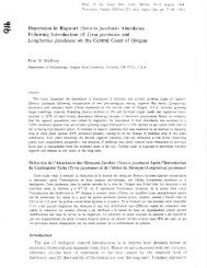
Figure 1 . Instrument set-up for surveying spatia l<br />
structures of trees. Two theodolites are in use ; th e<br />
instrument in the middle is a spotting laser .<br />
167