

Gönnert, G., Graßl, H., Kelletat, D., Kunz, H., Probst, B., von Storch, H ...
Gönnert, G., Graßl, H., Kelletat, D., Kunz, H., Probst, B., von Storch, H ...
Gönnert, G., Graßl, H., Kelletat, D., Kunz, H., Probst, B., von Storch, H ...
- TAGS
- kelletat
- kunz
- probst
- storch
- www.kuefo.de

Sie wollen auch ein ePaper? Erhöhen Sie die Reichweite Ihrer Titel.
YUMPU macht aus Druck-PDFs automatisch weboptimierte ePaper, die Google liebt.
GÖNNERT, G./ GRASSL, H./ KELLETAT, D./ KUNZ, H. / PROBST, B./ VON STORCH, H. / SÜNDERMANN, J.<br />
"Klimaänderung und Küstenschutz"<br />
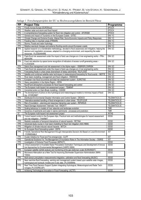
Anlage 1 Forschungsprojekte der EU zu Hochwassergefahren im Bereich Flüsse<br />
FP Project Title Programme<br />
FP2 Floods Across Europe (EUROflood) EPOCH<br />
FP2 Weather radar and storm and flood hazard EPOCH<br />
FP2 A comprehensive forecasting system for flood risk mitigation and control - AFORISM EPOCH<br />
FP3 Genesis and Impact of Tsunamis on the European Coasts - GITEC ENV 1C<br />
FP3 Climate Change and Extreme Events: Altered Risk, Socio-Economic Impacts and Policy Responses ENV 1C<br />
FP3 Flooding risks in mountain areas (FRIMAR) ENV 1C<br />
FP3 Storms, Floods and radar Hydrology ENV 1C<br />
FP3 Relative sea-level changes and extreme flooding events around European coasts ENV 1C<br />
FP4 Applied research on a transferable methodology, devoted to flood awareness and mitigation, helping the<br />
decision and negotiation processes, adapted to a changing environment, and respecting the water<br />
resources - FLOODAWARE<br />
ENV 2C<br />
FP4 Flash-flood risk assessment under the impact of land use changes an d river engineering works – FRA-<br />
MEWORK<br />
ENV 2C<br />
FP4 Flood risk reduction by space borne recognition of indicators of excess runoff generating areas –<br />
FLOODGEN<br />
ENV 2C<br />
FP4 Debris flow management and risk assessment in the Alpine region – DEBRISFLOWRISK ENV 2C<br />
FP4 Flash-flood risk assessment under the impact of land use changes an d river engineering works ENV 2C<br />
FP4 Forecasting floods in urban areas downstream of steep catchments- TELFLOOD ENV 2C<br />
FP4 Satellite and combined satellite-radar techniques in meteorological forecasting for flood events – MEFFE ENV 2C<br />
FP4 River basin modelling, management and flood mitigation - RIBAMOD ENV 2C<br />
FP4 European river flood occurrence and total risk assessment system - EUROTAS ENV 2C<br />
FP4 Heavy precipitation in the Alpine Region - HERA ENV 2C<br />
FP4 Runoff and atmospheric processes for flood hazard forecasting and control ENV 2C<br />
FP4 The European multi-hazard risk assessment project - TEMRAP ENV 2C<br />
FP4 Concerted action on Dam-Break modelling - CADAM ENV 2C<br />
FP4 The development of active on-line hydrological and meteorological models to minimise impact of flooding<br />
- HYDROMET<br />
ENV 2C<br />
FP4 Distributed Environmental Disaster Information and Control System - DEDICS TELEMATICS 2C<br />
FP4 Telematics-assisted handling of flood emergencies in urban areas - TELEFLEUR TELEMATICS 2C<br />
FP4 Risk of inundation – planning and response interactive user system - RIPARIUS TELEMATICS 2C<br />
FP4 Rapid Damage Assessment Telematic Tool - RADATT TELEMATICS 2C<br />
FP4 Scaling behaviour in models of river networks and landscape evolution TMR<br />
FP4 Dynamics of sediments and water in alpine catchments - processes and prediction TMR<br />
IC The European multi-hazard risk assessment project INTAS<br />
FP5 Torrent hazard control in the European Alps. Practical tools and methodologies for hazard assessment<br />
and risk mitigation - THARMIT<br />
EESD<br />
FP5 Realistic evaluation of temporal interactions of natural hazards - RETINA EESD<br />
FP5 Advanced study course in river basin modelling for flood risk mitigation (ASC-RBM) EESD<br />
FP5 Mitigation of climate-induced natural hazards - MITCH EESD<br />
FP5 An European flood forecasting system - EEFS EESD<br />
FP5 Friendly Operational Risk Management through Interoperable Decision Aid Based on Local Environment<br />
- FORMIDABLE<br />
IST<br />
FP5 Cluster Initiative for Flood and Fire emergencies - CLIFF IST<br />
FP5 Operational Solutions For The Management Of Inundation Risks In The Information Society – OSIRIS IST<br />
FP5 Investigation of Extreme Flood Processes (IMPACT) EESD<br />
FP5 Critical assessment of Available Radar Precipitation Estimation Techniques and Development of Innovative<br />
Approaches for Environmental Management (CARPE DIEM)<br />
EESD<br />
FP5 European satellite rainfall analysis and monitoring at the geo-stationary scale (EURAINSAT) EESD<br />
FP5 Microwave Attenuation as a New Tool for Improving Stormwater Supervision Administration (MAN-<br />
TISSA)<br />
EESD<br />
FP5 Multi-sensor precipitation measurements integration, calibration and flood forecasting (MUSIC) EESD<br />
FP5 Near real-time flood forecasting, warning and management system based upon satellite radar images,<br />
hydrological and hydraulic models and in-situ data. (FLOODMAN)<br />
EESD<br />
FP5 Real Time Flood Decision Support System Integrating Hydrological, Meteorological and Radar Technologies<br />
(FLOODRELIEF)<br />
EESD<br />
FP5 Achieving Technological Innovation in Flood Forecasting (ACTIF) EESD<br />
103