Desire for Greener Land
Desire for Greener Land
Desire for Greener Land

You also want an ePaper? Increase the reach of your titles
YUMPU automatically turns print PDFs into web optimized ePapers that Google loves.
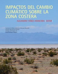
Gully G ccontrol<br />
by pla antationn<br />
of At triplex<br />
Morocco M<br />
Rehabilitation<br />
R<br />
of a gullied slope and gully<br />
control, by plantation n of Atriplex<br />
halimus<br />
fodderr<br />
shrubs.<br />
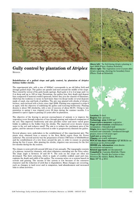
Above left: TThe<br />
field during g Atriplex plantting<br />
in<br />
April 2009 (PPhoto:<br />
Gudrun Schwilch) S<br />
Above right: : The vegetatio on cover 2 yearrs<br />
after<br />
Atriplex plantting,<br />
showing th he boundary feence<br />
(Photo: Gudrrun<br />
Schwilch)<br />
The<br />
experimenttal<br />
plot, with a size of 5000m m², correspondds<br />
to an old fa allow field and<br />
st trongly gullied slope. The gullies<br />
are paralle el and start aroound<br />
the middle e of the slope.<br />
They<br />
extend by retreat of the ggully<br />
heads ups slope. Each guully<br />
is 2 to 4 m large and 1 to<br />
2 m deep and uup<br />
to 120 m loong.<br />
Downslope,<br />
the gullies llose<br />
their dept th and deposit<br />
fa ans composed of material erooded<br />
upstream,<br />
be<strong>for</strong>e they jooin<br />
the channel<br />
of Hannanet,<br />
which w has the teendency<br />
to inciise<br />
its bed (mo ore than 4 m deeep)<br />
inside colluvial<br />
deposits<br />
made m of sand, cclay<br />
and beds of pebbles. Th he plot was plaanted<br />
with shru ubs of Atriplex<br />
ha alimus, and ennclosed<br />
with a ffence<br />
since Ap pril 2009. Plantiing<br />
was organised<br />
in strips 6<br />
m apart, with the<br />
objective of stabilizing the gullies and resstoring<br />
biodive ersity. Planting<br />
de ensity is aboutt<br />
760 shrubs/hha,<br />
with a rate of success of about 89.5%. Owing to late<br />
pl lantation in sppring<br />
it was irrrigated<br />
every 20 2 days duringg<br />
the summer r months. It is<br />
pl lanned to openn<br />
it again to graazing<br />
2.5 years s after its plantaation.<br />
Location: Se<br />
The<br />
objective oof<br />
the fencing to prevent encroachment<br />
off<br />
animals is to o improve the Region: Salé<br />
ve egetation coveer<br />
through reduuction<br />
of loss th hrough grazingg<br />
and reduced compaction of Technology<br />
th he soil. This immproves<br />
biodivversity<br />
and als so provides riccher<br />
and more e varied grass Conservatio<br />
fo odder in additioon<br />
to the fodder<br />
from the sh hrubs. The impproved<br />
cover density d retains Stage of inte<br />
water w in the soiil<br />
and reduces runoff. The ai im is to reducee<br />
the catchment<br />
area of the reclamation o<br />
gu ullies, and the amount of water<br />
collected in order to progreessively<br />
diminish<br />
the gullies. Origin: deve<br />
research and<br />
Several<br />
phasess<br />
were undertaaken<br />
in the est tablishment of f this experime ental plot: The project, recen<br />
pl lants were obbtained<br />
from a nursery in the t Beni Mellal<br />
region (from<br />
the Forest <strong>Land</strong> use: gr<br />
au uthority). The ssecond<br />
activityy<br />
was the prepa aration of holess<br />
(760 holes of 40x40x40cm) Climate: sem<br />
an nd the establisshment<br />
of a wire<br />
fence around<br />
the plot, in order to ensu ure no grazing WOCAT data<br />
du uring the first 2 years. After planting the sh hrubs, irrigationn<br />
was necessa ary <strong>for</strong> the first cdewocat.uni<br />
fe ew months duriing<br />
the dry seaason.<br />
DESIRE site<br />
his.eu/en/seh<br />
The<br />
climate is semi-arid<br />
with aaround<br />
450 mm m of rain annuaally.<br />
The topogr raphy consists Related appr<br />
of f a plateau, inccised<br />
by channnels,<br />
with short t tributaries exttending<br />
into the e Grou valley. Compiled by<br />
The<br />
slope anglle<br />
is between 10 and 50 %. % The soils oon<br />
the slope are often not Unesco-GN,<br />
de eveloped. Thee<br />
thick colluviuum,<br />
which is made m of erodible<br />
reddish sa and and clay, Sciences Hum<br />
ex xplains the deppth<br />
and width oof<br />
the gullies. The T economy rrelies<br />
on a sys stem based on Date: 09<br />
ce ereals and graazing.<br />
The inccome<br />
of this system is loww<br />
because of the extensive<br />
ch haracter and thhe<br />
reduction of<br />
yield due to degradation. d<br />
MMany<br />
changes are occurring,<br />
su uch as changees<br />
in land cover<br />
and in emig gration, land aabandonment<br />
and a increased<br />
lin nks to urban acctivities.<br />
th ehoul<br />
é province<br />
area: 0.005 km m<br />
on measure: ve<br />
ervention: reh<br />
of denuded lan<br />
eloped through<br />
d externally / in<br />
nt (