

ADB_book_18 April.qxp - Himalayan Document Centre - icimod
ADB_book_18 April.qxp - Himalayan Document Centre - icimod
ADB_book_18 April.qxp - Himalayan Document Centre - icimod
- No tags were found...

You also want an ePaper? Increase the reach of your titles
YUMPU automatically turns print PDFs into web optimized ePapers that Google loves.
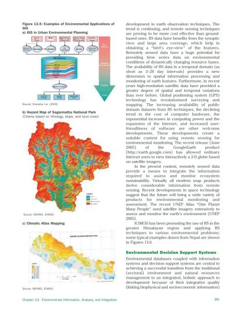
Figure 13.5: Examples of Environmental Applications ofGISa) GIS in Urban Environmental PlanningSource: Shrestha t al. (2003)b) Hazard Map of Sagarmatha National Park(Criteria based on lithology, slope, and land cover)Source: MENRIS, ICIMOD.c) Climatic Atlas Mappingdevelopment in earth observation techniques. Thetrend is continuing, and remote sensing techniquesare proving to be more cost effective than groundbasedones. RS data have benefits from the synopticview and large area coverage, which help inobtaining a “bird’s eye-view” of the features.Remotely sensed data have a huge potential forproviding time series data on environmentalconditions of dynamically changing resource bases.The availability of RS data in a temporal domain (asshort as 3–20 day intervals) provides a newdimension to spatial information processing andmonitoring of earth features. Furthermore, in recentyears high-resolution satellite data have provided agreater degree of spatial and temporal variationsthan ever before. Global positioning system (GPS)technology has revolutionized surveying andmapping. The increasing availability of publicdomain datasets from RS techniques, the decliningtrend in the cost of computer hardware, theexponential increases in computing power and theexpansion of the Internet, and increased userfriendlinessof software are other welcomedevelopments. These developments create asuitable context for using remote sensing forenvironmental monitoring. The recent release (June2005) of the GoogleEarth product(http://earth.google.com) has allowed ordinaryInternet users to view interactively a 3-D globe basedon satellite imagery.In the present context, remotely sensed dataprovide a means to integrate the informationrequired to assess and monitor ecosystemsustainability. Virtually all modern map productsderive considerable information from remotesensing. Recent developments in space technologysuggest that the future will bring a wide variety ofproducts for environmental monitoring andassessment. The recent UNEP Atlas “One PlanetMany People” used satellite imagery extensively toassess and monitor the earth’s environment (UNEP2005).ICIMOD has been promoting the use of RS in thegreater <strong>Himalayan</strong> region and applying RStechniques to various environmental problems;some typical examples drawn from Nepal are shownin Figures 13.6.Source: MENRIS, ICIMOD.Environmental Decision Support SystemsEnvironmental databases coupled with informationsystems and decision support systems are central toachieving a successful transition from the traditional(sectoral) environment and natural resourcesmanagement to an integrated, holistic approach todevelopment because of their integrative quality(linking biophysical and socioeconomic information)Chapter 13: Environmental Information, Analysis, and Integration201


