

ADB_book_18 April.qxp - Himalayan Document Centre - icimod
ADB_book_18 April.qxp - Himalayan Document Centre - icimod
ADB_book_18 April.qxp - Himalayan Document Centre - icimod
- No tags were found...

You also want an ePaper? Increase the reach of your titles
YUMPU automatically turns print PDFs into web optimized ePapers that Google loves.
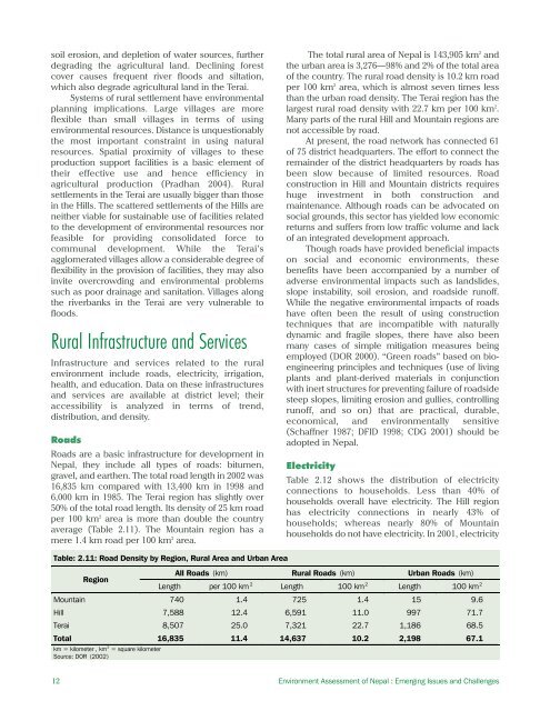
soil erosion, and depletion of water sources, furtherdegrading the agricultural land. Declining forestcover causes frequent river floods and siltation,which also degrade agricultural land in the Terai.Systems of rural settlement have environmentalplanning implications. Large villages are moreflexible than small villages in terms of usingenvironmental resources. Distance is unquestionablythe most important constraint in using naturalresources. Spatial proximity of villages to theseproduction support facilities is a basic element oftheir effective use and hence efficiency inagricultural production (Pradhan 2004). Ruralsettlements in the Terai are usually bigger than thosein the Hills. The scattered settlements of the Hills areneither viable for sustainable use of facilities relatedto the development of environmental resources norfeasible for providing consolidated force tocommunal development. While the Terai’sagglomerated villages allow a considerable degree offlexibility in the provision of facilities, they may alsoinvite overcrowding and environmental problemssuch as poor drainage and sanitation. Villages alongthe riverbanks in the Terai are very vulnerable tofloods.Rural Infrastructure and ServicesInfrastructure and services related to the ruralenvironment include roads, electricity, irrigation,health, and education. Data on these infrastructuresand services are available at district level; theiraccessibility is analyzed in terms of trend,distribution, and density.RoadsRoads are a basic infrastructure for development inNepal, they include all types of roads: bitumen,gravel, and earthen. The total road length in 2002 was16,835 km compared with 13,400 km in 1998 and6,000 km in 1985. The Terai region has slightly over50% of the total road length. Its density of 25 km roadper 100 km 2 area is more than double the countryaverage (Table 2.11). The Mountain region has amere 1.4 km road per 100 km 2 area.The total rural area of Nepal is 143,905 km 2 andthe urban area is 3,276—98% and 2% of the total areaof the country. The rural road density is 10.2 km roadper 100 km 2 area, which is almost seven times lessthan the urban road density. The Terai region has thelargest rural road density with 22.7 km per 100 km 2 .Many parts of the rural Hill and Mountain regions arenot accessible by road.At present, the road network has connected 61of 75 district headquarters. The effort to connect theremainder of the district headquarters by roads hasbeen slow because of limited resources. Roadconstruction in Hill and Mountain districts requireshuge investment in both construction andmaintenance. Although roads can be advocated onsocial grounds, this sector has yielded low economicreturns and suffers from low traffic volume and lackof an integrated development approach.Though roads have provided beneficial impactson social and economic environments, thesebenefits have been accompanied by a number ofadverse environmental impacts such as landslides,slope instability, soil erosion, and roadside runoff.While the negative environmental impacts of roadshave often been the result of using constructiontechniques that are incompatible with naturallydynamic and fragile slopes, there have also beenmany cases of simple mitigation measures beingemployed (DOR 2000). “Green roads” based on bioengineeringprinciples and techniques (use of livingplants and plant-derived materials in conjunctionwith inert structures for preventing failure of roadsidesteep slopes, limiting erosion and gullies, controllingrunoff, and so on) that are practical, durable,economical, and environmentally sensitive(Schaffner 1987; DFID 1998; CDG 2001) should beadopted in Nepal.ElectricityTable 2.12 shows the distribution of electricityconnections to households. Less than 40% ofhouseholds overall have electricity. The Hill regionhas electricity connections in nearly 43% ofhouseholds; whereas nearly 80% of Mountainhouseholds do not have electricity. In 2001, electricityTable: 2.11: Road Density by Region, Rural Area and Urban AreaRegionAll Roads (km) Rural Roads (km) Urban Roads (km)Length per 100 km 2 Length 100 km 2 Length 100 km 2Mountain 740 1.4 725 1.4 15 9.6Hill 7,588 12.4 6,591 11.0 997 71.7Terai 8,507 25.0 7,321 22.7 1,<strong>18</strong>6 68.5Total 16,835 11.4 14,637 10.2 2,198 67.1km = kilometer , km 2 = square kilometerSource: DOR (2002)12 Environment Assessment of Nepal : Emerging Issues and Challenges


