- Page 1 and 2:
Transport and Works Act 1992Transpo
- Page 4:
CONTENTSVOLUME 1INTRODUCTION, SCHEM
- Page 8:
Evergreen 3 Project: The ChilternRa
- Page 12:
CONTENTS1 INTRODUCTION 11.1 PURPOSE
- Page 15:
capacity - which was completed in 2
- Page 19 and 20:
identified for railway use in the C
- Page 22:
KEY:Scheme BoundaryBicester North S
- Page 25 and 26:
Currently the rail corridor is used
- Page 27 and 28:
The CRCL plans for new platforms at
- Page 29 and 30:
• cumulatively significant effect
- Page 31 and 32:
significant effect may arise in rel
- Page 33 and 34:
types arising from the project, (eg
- Page 35 and 36:
• construction of new infrastruct
- Page 38 and 39:
3.3.3 In addition along the corrido
- Page 40:
WarwickshireNorthamptonshireTingewi
- Page 43 and 44:
Habitats3.4.8 ERM undertook a preli
- Page 45 and 46:
Habitats3.4.17 The works may involv
- Page 47 and 48:
Due to the limited land-take of the
- Page 50 and 51:
3.6 ARCHAEOLOGY AND CULTURAL HERITA
- Page 52:
Although smaller, the settlements o
- Page 56 and 57:
3.7 TRAFFIC AND TRANSPORT3.7.1 Duri
- Page 58 and 59:
3.9.3 The purpose of the land quali
- Page 60 and 61:
4 METHODOLOGIES FOR ASSESSING ENVIR
- Page 62 and 63:
Figure 4.1Diagram Illustrating Nois
- Page 64 and 65:
noise level together with the durat
- Page 66 and 67:
from station activities. Since the
- Page 68 and 69:
4.3.4 The methodology will be based
- Page 70 and 71:
Evaluation of Receptor Sensitivity4
- Page 72 and 73:
Table 4.7 Levels of Significance of
- Page 74 and 75:
4.4 ECOLOGYMethodologyIntroduction4
- Page 76 and 77:
4.5 WATER RESOURCESMethodology4.5.1
- Page 78 and 79:
Evaluation Criteria4.5.7 With parti
- Page 80 and 81:
ased on archaeological work underta
- Page 82 and 83:
4.7 TRAFFIC AND TRANSPORTMethodolog
- Page 84 and 85:
Subject AreaMagnitude of EffectMajo
- Page 86 and 87:
not found.. This will be used to de
- Page 88 and 89:
• Best practices for soils handli
- Page 90 and 91:
5 PREPARATION OF THE ENVIRONMENTAL
- Page 92:
Annex AProposed Consultation Listfo
- Page 95 and 96:
ERM has over 100 officesAcross the
- Page 98 and 99:
CONTENTSB1 PREFACE 1B1.1 THE PROJEC
- Page 100 and 101:
B1PREFACEB1.1 THE PROJECTB1.1.1B1.1
- Page 102 and 103:
B1.4.1The “site”, for the purpo
- Page 104 and 105:
B2PUBLIC INFORMATION AND COMPLAINTS
- Page 106 and 107:
B3HOURS OF WORKINGB3.1.1B3.1.2B3.1.
- Page 108 and 109:
B4.1.2All working areas shall be in
- Page 110 and 111:
B4.4 ACCESS AND LOADINGB4.4.1B4.4.2
- Page 112 and 113:
Contaminated Materials (Special Pre
- Page 114 and 115:
B5TRAFFIC AND TRANSPORTB5.1 OVERVIE
- Page 116 and 117:
that steps are unavoidable, an alte
- Page 118 and 119:
(i)(ii)(iii)(iv)(v)The provision of
- Page 120 and 121:
(ii) For control of traffic leaving
- Page 122 and 123:
B6.1.5B6.1.6In order to ensure that
- Page 124 and 125:
B6.2.2In order to ensure that these
- Page 126 and 127:
xvi.xvii.Plan site layout and take
- Page 128 and 129:
B8DISPOSAL OF WASTE AND CONTAMINATE
- Page 130 and 131:
B8.2.8B8.2.9B8.2.10Where necessary,
- Page 132 and 133:
B9.2.3B9.2.4B9.2.5B9.2.6B9.2.7Provi
- Page 134 and 135:
PPG05: Works and maintenance in or
- Page 136 and 137:
B9.8.1B9.8.2B9.8.3B9.8.4B9.8.5B9.8.
- Page 138 and 139:
B9.11 EMERGENCY AND UNFORESEEN EVEN
- Page 140 and 141:
B10.2.3B10.2.4B10.2.5B10.2.6B10.2.7
- Page 142 and 143:
B10.4.7All construction works, incl
- Page 144 and 145:
ReptilesB10.4.20In areas where high
- Page 146 and 147:
B10.7.2All invasive species recorde
- Page 148 and 149:
B11.2.1A programme of building insp
- Page 150:
Annex CSummary of AlternativesConsi
- Page 153 and 154:
This Annex describes the Options th
- Page 155 and 156:
C1.1.1Chinnor BranchThe former Prin
- Page 157 and 158:
C1.2.1Routes via the Bicester Milit
- Page 160:
Figure C2Possible Station Locations
- Page 163 and 164:
the east of the station which would
- Page 165 and 166:
Bicester Interchange StationThe Che
- Page 167 and 168:
Site Options Reason for Selection/R
- Page 169 and 170:
Site Options Reason for Selection/R
- Page 171 and 172:
Name: Langford Lane LevelCrossingOS
- Page 174 and 175: Name: FootbridgeOS Grid Ref.: Not k
- Page 176 and 177: crossing.Name: Manor Farm No 1 (aka
- Page 178 and 179: access route to Middle Farm in lieu
- Page 180: Annex DDetails of the Noise andVibr
- Page 184 and 185: D1INTRODUCTIONSection 6 of the ES s
- Page 186 and 187: in order to evaluate the noise clim
- Page 188 and 189: D2.1.2ResultsAmbient noise levels w
- Page 190 and 191: Table D2.4Attended Measurement Surv
- Page 192 and 193: MeasurementPositionDate Time Durati
- Page 194 and 195: Date Time DurationNoise Level (Corr
- Page 196 and 197: Date Time DurationNoise Level (Corr
- Page 198 and 199: 70 dB(A) in rural, suburban and urb
- Page 200 and 201: Table D3.2Plant Inventory Represent
- Page 202 and 203: Table D3.8Plant Inventory Represent
- Page 204 and 205: D4OPERATIONAL NOISED4.1 NOISE STAND
- Page 206 and 207: Noise levels (a) Corresponding to t
- Page 208 and 209: D5RAIL NOISE MODELLING METHODOLOGYD
- Page 210 and 211: part of the baseline between Oxford
- Page 212 and 213: Table D5.2 Modelled Train Movements
- Page 214 and 215: an existing through line which cont
- Page 216 and 217: Vibration measurements were carried
- Page 218: Peak Particle Velocity (PPV)Peak Pa
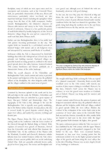
- Page 222 and 223: Upper ThamesClay ValesCharacter Are
- Page 226 and 227: Vales of the White Horseand Aylesbu
- Page 228: Industrial activities at Abingdon a
- Page 232: Annex F1HRAS
- Page 236 and 237: F1ANNEX F1- HABITATS REGULATIONS AS
- Page 238 and 239: F2APPROACHThe approach taken to inf
- Page 240 and 241: to be favourable. They are set by N
- Page 242 and 243: Site name/area/distance fromdevelop
- Page 244 and 245: Site name/area/distance fromdevelop
- Page 246 and 247: Site name/area/distance fromdevelop
- Page 248 and 249: Site name/area/distance fromdevelop
- Page 250 and 251: F4DEVELOPMENT ACTIVITIES AND IMPACT
- Page 252 and 253: Table 4.1Potential Impact / Sensiti
- Page 254: Annex F2Breeding Birds
- Page 257 and 258: The areas with the highest breeding
- Page 259 and 260: Survey methodologyFour rounds of su
- Page 261 and 262: Subsequent analysis of the data col
- Page 263 and 264: Table 3. Chiltern Railway bird spec
- Page 265 and 266: ● Dunnock 2prs 2prs 4prs B 3prs 2
- Page 267 and 268: 16. Grandpont17. Hinksey fields18.
- Page 269 and 270: Other species of note included spar
- Page 271 and 272: There were eight UK BAP species. Th
- Page 273 and 274: line towards Bicester and the mainl
- Page 275 and 276:
There were x UK BAP species: skylar
- Page 277 and 278:
ReferencesBirdLife International (2
- Page 280 and 281:
ERMChiltern LineBat Dusk and Dawn S
- Page 282 and 283:
Chiltern Line September 2009Bat Dus
- Page 284 and 285:
Chiltern Line September 2009Bat Dus
- Page 286 and 287:
Chiltern Line September 2009Bat Dus
- Page 288 and 289:
Chiltern Line September 2009Bat Dus
- Page 290 and 291:
Chiltern Line September 2009Bat Dus
- Page 292 and 293:
Chiltern Line September 2009Bat Dus
- Page 294 and 295:
Chiltern Line September 2009Bat Dus
- Page 296 and 297:
Chiltern Line September 2009Bat Dus
- Page 298 and 299:
Chiltern Line September 2009Bat Dus
- Page 300:
Chiltern Line September 2009Bat Dus
- Page 365 and 366:
Chiltern Line September 2009Bat Dus
- Page 368:
Annex F4Great Crested Newts
- Page 371 and 372:
F4-2 METHODSF4-2.1DESK STUDY AND CO
- Page 373 and 374:
crested newts (see Table 3.1). This
- Page 375 and 376:
F4-2.4.5Egg searchThe leaves of sub
- Page 377 and 378:
F4-3 RESULTSF4-3.1DESK STUDY AND CO
- Page 379 and 380:
Waterbody HSI ScoreRatingNumber34 0
- Page 381 and 382:
F4-4 SUMMARY OF FINDINGS AND RECOMM
- Page 383 and 384:
ERMChiltern Line, OxfordGreat Crest
- Page 385 and 386:
Chiltern Line, Oxford April 2009Gre
- Page 387:
Chiltern Line, Oxford April 2009Gre
- Page 401 and 402:
ERM Habitat Suitability Survey Resu
- Page 404 and 405:
3 APPENDIX 3 WATERBODY PHOTOGRAPHSF
- Page 406 and 407:
Figure 3.4Pond 8a and bFigure 3.5Po
- Page 408 and 409:
Figure 3.8 Pond 11Figure 3.9 Pond 1
- Page 410 and 411:
Figure 3.12Pond 13cFigure 3.13 Pond
- Page 412 and 413:
Figure 3.16Pond 18cFigure 3.17 Pond
- Page 414 and 415:
Figure 3.20 Pond 28Figure 3.21 Pond
- Page 416 and 417:
Figure 3.24 Pond 38Figure 3.25Pond
- Page 418 and 419:
Figure 3.28 Pond 44Figure 3.29Pond
- Page 420 and 421:
Great Crested Newt Presence Survey
- Page 422 and 423:
Great Crested Newt Presence Survey
- Page 424 and 425:
Great Crested Newt Presence Survey
- Page 426 and 427:
Great Crested Newt Presence Survey
- Page 428 and 429:
Great Crested Newt Presence Survey
- Page 430 and 431:
Great Crested Newt Presence Survey
- Page 432 and 433:
Great Crested Newt Presence Survey
- Page 434 and 435:
Great Crested Newt Presence Survey
- Page 436 and 437:
Great Crested Newt Presence Survey
- Page 438 and 439:
Great Crested Newt Presence Survey
- Page 440 and 441:
Great Crested Newt Presence Survey
- Page 442 and 443:
Great Crested Newt Presence Survey
- Page 444 and 445:
Great Crested Newt Presence Survey
- Page 446 and 447:
Great Crested Newt Presence Survey
- Page 448 and 449:
Great Crested Newt Presence Survey
- Page 450 and 451:
Great Crested Newt Presence Survey
- Page 452 and 453:
Great Crested Newt Presence Survey
- Page 454 and 455:
Great Crested Newt Presence Survey
- Page 456:
Weather ConditionsDate Range Temp (
- Page 460 and 461:
ERMChiltern Line, Oxford - Bicester
- Page 462 and 463:
Chiltern Line, Oxford - Bicester Au
- Page 464 and 465:
Chiltern Line, Oxford - Bicester Au
- Page 466 and 467:
Chiltern Line, Oxford - Bicester Au
- Page 468 and 469:
Chiltern Line, Oxford - Bicester Au
- Page 470 and 471:
Chiltern Line, Oxford - Bicester Au
- Page 472 and 473:
Chiltern Line, Oxford - Bicester Au
- Page 474:
Chiltern Line, Oxford - Bicester Au
- Page 493 and 494:
Chiltern Line, Oxford - Bicester Au
- Page 495 and 496:
Chiltern Line, Oxford - Bicester Au
- Page 498:
Annex F7Reptiles
- Page 501 and 502:
ERMChiltern LineReptile ReportSepte
- Page 503 and 504:
Chiltern Line September 2009Reptile
- Page 505 and 506:
Chiltern Line September 2009Reptile
- Page 507 and 508:
Chiltern Line September 2009Reptile
- Page 509 and 510:
Chiltern Line September 2009Reptile
- Page 511 and 512:
Chiltern Line September 2009Reptile
- Page 513 and 514:
Chiltern Line September 2009Reptile
- Page 515:
Chiltern Line September 2009Reptile
- Page 533 and 534:
Chiltern Line September 2009Reptile
- Page 535 and 536:
Chiltern Line September 2009Reptile
- Page 537 and 538:
Chiltern Line September 2009Reptile
- Page 540:
Annex G1Legislation and PolicyConte
- Page 543 and 544:
and structured approach to local wa
- Page 545 and 546:
generally the Environment Agency, b
- Page 547 and 548:
The Sequential TestThe Sequential T
- Page 549 and 550:
Policy NE9 - Flood Risk Assessment
- Page 552:
Annex G2Flood Risk Assessment(FRA)
- Page 556 and 557:
Chiltern Railways Bicester to Oxfor
- Page 558 and 559:
4 Surface Water Runoff Assessments
- Page 560 and 561:
The railway is an essential infrast
- Page 562 and 563:
2 Description of Scheme Works2.1 Ov
- Page 564 and 565:
ParkwaysidingsAP15Gosford and Water
- Page 566 and 567:
Figure 32.4 AP3 - Bicester Town Sta
- Page 568 and 569:
Figure 52.6 AP5 - OXD40 Underbridge
- Page 570 and 571:
Figure 72.8 AP7 - Merton Footbridge
- Page 572 and 573:
Figure 92.10 AP9 - Oddington Footbr
- Page 574 and 575:
Figure 112.12 AP11 - Islip Station
- Page 576 and 577:
Figure 132.14 AP13 - Water Eaton No
- Page 578 and 579:
Figure 152.16 AP15 - Gosford and Wa
- Page 580 and 581:
Figure 172.18 AP17 - Aristotle Lane
- Page 582 and 583:
Figure 192.20 AP19 - Oxford Station
- Page 584 and 585:
3 Application of the Sequential Tes
- Page 586 and 587:
commitments to implement drainage s
- Page 588 and 589:
2. The topographic model appears to
- Page 590 and 591:
Avoids impacting upon both a Schedu
- Page 592 and 593:
It should be noted that the crossin
- Page 594 and 595:
600 mm freeboard over the 1 in 100
- Page 596 and 597:
AssessmentPointFloodZoneSTRequired?
- Page 598 and 599:
Greenfield runoff rates;Current Bro
- Page 600 and 601:
Table 3 Summary of impermeable runo
- Page 602 and 603:
5 ConclusionsA Level 2 Flood Risk A
- Page 604 and 605:
7 Appendix 1: Surface Water RunoffS
- Page 606:
Annex HCultural Heritage andArchaeo
- Page 609 and 610:
RCHME 1996 Recording Historic Build
- Page 611 and 612:
OARef.NoFeatureType10 ConservationA
- Page 613 and 614:
Table H2.2Gazetteer of Undesignated
- Page 615 and 616:
OARef. No128 ArchaeologicalInvestig
- Page 617 and 618:
OA Feature Type Description SourceR
- Page 619 and 620:
OARef. No198 ArchaeologicalInvestig
- Page 621 and 622:
OA Feature Type Description SourceR
- Page 623 and 624:
OARef. No264 ArchaeologicalInvestig
- Page 625 and 626:
OA Feature Type Description SourceR
- Page 627 and 628:
OA Feature Type Description SourceR
- Page 629 and 630:
OA Feature Type Description SourceR
- Page 631 and 632:
OARef. No351Feature Type Descriptio
- Page 634:
219234251#260 273!235! !!!259! !272
- Page 638:
Annex I1S-Paramics ModelledHighway
- Page 642:
NBicester RoadA4260 Oxford RoadKidl
- Page 646 and 647:
Bus Capacity SurveyService 2/2A/2B/
- Page 648 and 649:
Bus Capacity SurveyService 7A/7B -
- Page 650 and 651:
Bus Capacity SurveyService S5 - AM
- Page 652 and 653:
Bus Capacity SurveyService 500 - AM
- Page 654 and 655:
Bus Capacity SurveyService 700 - AM
- Page 656 and 657:
Bicester Bus Capacity SurveyService
- Page 658 and 659:
Bicester Bus Capacity SurveyService
- Page 660:
Annex I3Personal Injury Road Traffi
- Page 670:
NCTUBBS LANE FOOT CROSSINGTO BE REP
- Page 674:
Annex I5Parking Accumulation
- Page 678:
Annex I6S-Paramics Model Outputs:Bi
- Page 688 and 689:
09:5009:4009:3009:2009:1009:0008:50
- Page 690 and 691:
09:5009:4009:3009:2009:1009:0008:50
- Page 692 and 693:
18:5018:4018:3018:2018:1018:0017:50
- Page 694 and 695:
450Average Journey Time for Soutbou
- Page 696 and 697:
450Average Journey Time for Northbo
- Page 698:
Annex JAir Quality
- Page 701 and 702:
J2DISPERSION MODELLING METHODOLOGY
- Page 703 and 704:
J2.3 MODEL INPUTSJ2.3.1Moving Train
- Page 705 and 706:
J2.3.3Time varying emissionsAs the
- Page 707 and 708:
J3DMRB SCREENING FOR ROAD TRAFFICJ3
- Page 709 and 710:
Table J3.2Traffic Data (as Annual A
- Page 711 and 712:
J4CALCULATION OF ACID DEPOSITION AN
- Page 714:
Annex KSupporting Calculations forC
- Page 717 and 718:
Chiltern Railways Service Level - E
- Page 720 and 721:
Table L1Contaminated Land Risk Rank
- Page 722 and 723:
- Recreational or other shortterm/s
- Page 724:
Project Team ConsultantsArdent Mana


