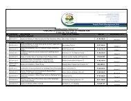
Chapter 11 - Sedibeng District Municipality
Chapter 11 - Sedibeng District Municipality
Chapter 11 - Sedibeng District Municipality

You also want an ePaper? Increase the reach of your titles
YUMPU automatically turns print PDFs into web optimized ePapers that Google loves.
7.1.3 Rail Network<br />
The Midvaal area is w ell served in terms of rail infrastructure, w ith north-south and<br />
east-w est railw ay lines traversing the area. The commuter rail services are mainly<br />
operated on railw ay lines ow ned by the South African Rail Commuter Corporation.<br />
The railw ay line running from north to south through Midvaal adjacent to the R59<br />
freeway is operated on a Spoornet line and some of the commuter rail services are<br />
also functioning on Spoornet lines. There are no proper inter-modal transfer facilities<br />
in Midvaal. The Meyerton railw ay station how ever includes a formal taxi rank and bus<br />
terminus. Most of the public transport users in Midvaal make use of taxis,<br />
notw ithstanding the fact that rail transport is the cheapest mode of transport. The low<br />
density residential development around stations may be one of the main causes of<br />
this. In summary, it can be said that from a transport point of view , the study area has<br />
the necessary elements required for corridor development, namely more than one<br />
mode of transport as well as a Mobility Route and Activity Spine, w ith frequent<br />
intersections on these roads.<br />
7.1.4 Framework Plan<br />
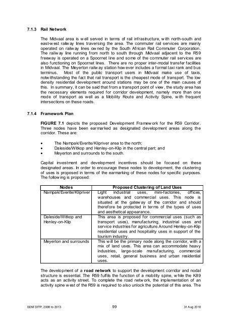
FIGURE 7.1 depicts the proposed Development Framew ork for the R59 Corridor.<br />
Three nodes have been earmarked as designated development areas along the<br />
corridor. These are:<br />
• The Nampak/Everite/Klipriver area to the north;<br />
• Daleside/Witkop and Henley-on-Klip in the central part; and<br />
• Meyerton and surrounds to the south.<br />
Capital investment and development incentives should be focused on these<br />
designated areas. In order to encourage these nodes to development, the clustering<br />
of uses is proposed in terms of the earmarking of these nodes for specific purposes.<br />
The follow ing is proposed:<br />
Nodes<br />
Proposed Clustering of Land Uses<br />
Nampak/Everite/Klipriver Light industrial uses, mini-factories, offices,<br />
warehouses and commercial uses. This node is<br />
situated at the gatew ay of the corridor and should<br />
therefore be protected in terms of the types of uses<br />
and aesthetical appearance.<br />
Daleside/Witkop and<br />
Henley-on-Klip<br />
This area is proposed for commercial uses (such as<br />
transport uses), manufacturing, industrial uses and<br />
service industries for agriculture.Around Henley-on-Klip<br />
residential uses and hospitality uses in support of the<br />
tourism industry.<br />
Meyerton and surrounds This w ill be the primary node along the corridor, with a<br />
mix of land uses. This area can accommodate heavy<br />
industries, large-scale manufacturing, commercial<br />
uses, retail, general business and urban residential<br />
uses.<br />
The development of a road network to support the development corridor and nodal<br />
structure is essential. The R59 fulfils the function of a mobility spine, w hile the K89<br />
acts as an activity street. To complete the road netw ork, the implementation of an<br />
activity spine w est of the R59 is required to also unlock the potential of this area. The<br />
SDM DITP, 2008 to 2013 99 31 Aug 2010