

Infrastructure Delivery Plan (Feb 2013) - Runnymede Borough Council
Infrastructure Delivery Plan (Feb 2013) - Runnymede Borough Council
Infrastructure Delivery Plan (Feb 2013) - Runnymede Borough Council

You also want an ePaper? Increase the reach of your titles
YUMPU automatically turns print PDFs into web optimized ePapers that Google loves.
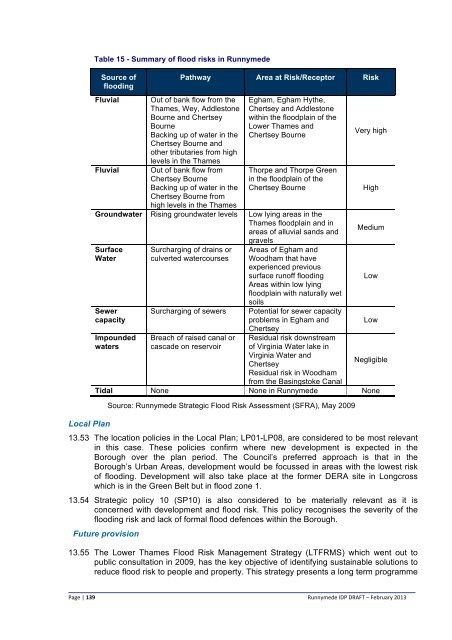
Table 15 - Summary of flood risks in <strong>Runnymede</strong><br />
Source of<br />
flooding<br />
Fluvial<br />
Fluvial<br />
Pathway Area at Risk/Receptor Risk<br />
Out of bank flow from the<br />
Thames, Wey, Addlestone<br />
Bourne and Chertsey<br />
Bourne<br />
Backing up of water in the<br />
Chertsey Bourne and<br />
other tributaries from high<br />
levels in the Thames<br />
Out of bank flow from<br />
Chertsey Bourne<br />
Backing up of water in the<br />
Chertsey Bourne from<br />
Egham, Egham Hythe,<br />
Chertsey and Addlestone<br />
within the floodplain of the<br />
Lower Thames and<br />
Chertsey Bourne<br />
Thorpe and Thorpe Green<br />
in the floodplain of the<br />
Chertsey Bourne<br />
high levels in the Thames<br />
Groundwater Rising groundwater levels Low lying areas in the<br />
Thames floodplain and in<br />
areas of alluvial sands and<br />
gravels<br />
Surface<br />
Water<br />
Local <strong>Plan</strong><br />
Sewer<br />
capacity<br />
Impounded<br />
waters<br />
Surcharging of drains or<br />
culverted watercourses<br />
Surcharging of sewers<br />
Breach of raised canal or<br />
cascade on reservoir<br />
Areas of Egham and<br />
Woodham that have<br />
experienced previous<br />
surface runoff flooding<br />
Areas within low lying<br />
floodplain with naturally wet<br />
soils<br />
Potential for sewer capacity<br />
problems in Egham and<br />
Chertsey<br />
Residual risk downstream<br />
of Virginia Water lake in<br />
Virginia Water and<br />
Chertsey<br />
Residual risk in Woodham<br />
from the Basingstoke Canal<br />
Very high<br />
High<br />
Medium<br />
Low<br />
Low<br />
Negligible<br />
Tidal None None in <strong>Runnymede</strong> None<br />
Source: <strong>Runnymede</strong> Strategic Flood Risk Assessment (SFRA), May 2009<br />
13.53 The location policies in the Local <strong>Plan</strong>; LP01-LP08, are considered to be most relevant<br />
in this case. These policies confirm where new development is expected in the<br />
<strong>Borough</strong> over the plan period. The <strong>Council</strong>’s preferred approach is that in the<br />
<strong>Borough</strong>’s Urban Areas, development would be focussed in areas with the lowest risk<br />
of flooding. Development will also take place at the former DERA site in Longcross<br />
which is in the Green Belt but in flood zone 1.<br />
13.54 Strategic policy 10 (SP10) is also considered to be materially relevant as it is<br />
concerned with development and flood risk. This policy recognises the severity of the<br />
flooding risk and lack of formal flood defences within the <strong>Borough</strong>.<br />
Future provision<br />
13.55 The Lower Thames Flood Risk Management Strategy (LTFRMS) which went out to<br />
public consultation in 2009, has the key objective of identifying sustainable solutions to<br />
reduce flood risk to people and property. This strategy presents a long term programme<br />
Page | 139<br />
<strong>Runnymede</strong> IDP DRAFT – <strong>Feb</strong>ruary <strong>2013</strong>


